
2018 TNF Lavaredo 120K Experience (Part 4)
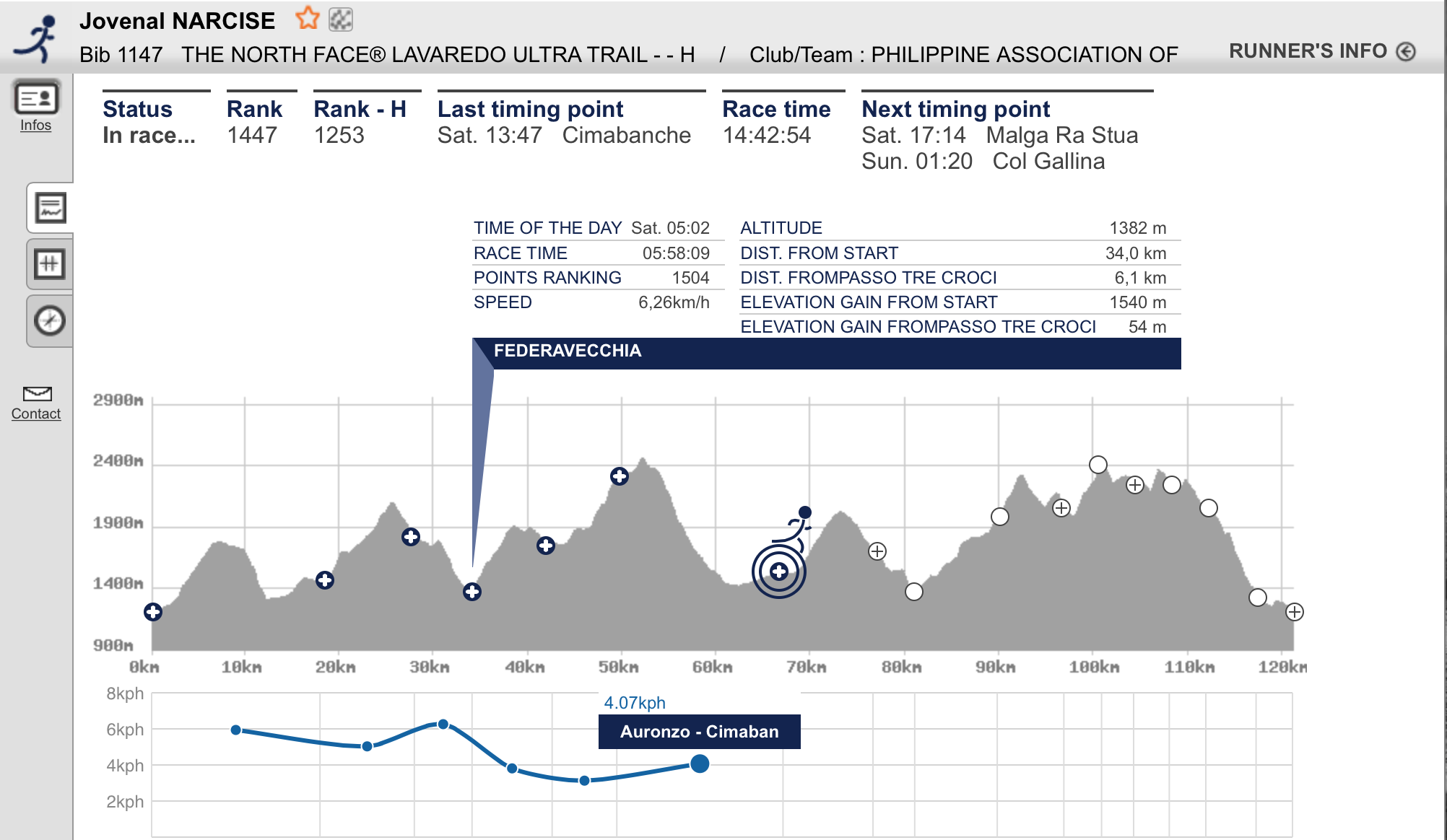
@ Federavecchia (Km 33.5)/First Cut-Off Time Checkpoint
Reaching this First Cut-Off Time Checkpoint at Federavecchia within 6:30 hours was my primary concern and target just to redeem myself from my frustration on my previous performance at the MIUT in Madeira, Portugal on the last week of April this year. I was happy and excited that I was able to build-up a buffer time of 32 minutes. With my age of 66 years old, I could be the happiest person among the runners that reached the said Aid Station.
I immediately brought out my almost empty Salomon Bottle, drank the remaining liquid and had it filled up with water, dropped one tablet of NUUN, and placed it back on the vest. Brought out an empty Ziplock bag from my vest and immediately filled it with apple bite cuts and dried apricot and immediately left the Aid Station. It took me less than 2 minutes to do all these things. But as soon as I left the Aid Station, I was facing a straight steep uphill climb.
I started to eat what I took from the Aid Station while I was hiking up the uphill climb which is an asphalted road that can accommodate three runners abreast with each other. The uphill climb consisted of more switchbacks and it lasted for about 2.5 kilometers. It took me two times to eat the fruit bites from the ziplock and they provided me the much needed energy to reach the peak of the third climb of the course and was able to reach Plan Maccetto which is almost Km 39 from the Start. From this point, I started to run on a single track trail which was a soft ground with with lots of small grass around. Even if this place is still considered in a higher elevation, my “running nose” and numbing hands had stopped and the temperature was becoming warmer to my body. After about 3 kilometers of running downhill, I finally reached the edge of a body of water which is called the Lake Misurina!
Tip: You can master the art of filling the Aid Station’s food with an empty Ziplock Bag. It will save you some time, instead of standing while eating your food at the Aid Station. Keep moving while you are eating and hydrating.
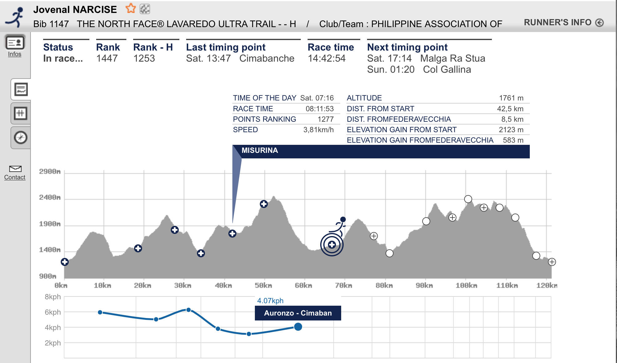
Lake Misurina
Lake Misurina is a beautiful lake with very clear water. I was tempted to take a “selfie” and picture of the lake & the surrounding mountains but I promised myself not to bring out my cellphone during the course of my run. The three of us Pinoy runners had talked about not having pictures along the course since it will delay our run/hike from Aid Station/Checkpoint to the next one. Knowing that there are Professional Photographers along the course in different strategic locations, there was no need for “selfies” or picture-taking on the scenery. It was another 1.2 to 2 kilometers run on a wide dirt road surrounding the Lake before I reached a Lady Marshal who was holding a Time Scanner. She tagged me and I asked her how far was the next Cut-Off Time Checkpoint and she replied “10 kilometers”. But looking on the map/elevation profile on my Race Bib, it indicates a distance of only 7 kilometers! I wonder which is one telling the truth, the Lady Marshal or the Map printed on the Race Bib?
After I exited from the periphery of Lake Misurina, I was now following an asphalted road that was going up to the mountain but the runners were directed to run along the dirt path/trail beside the paved road as shown and depicted by the trail markings. It was doing an alternate hike on the paved road and then going back to the dirt track beside the road and back again to the paved road at this point using my trekking poles. I was able to pass by an Asian guy and I started to have a conversation with him. He told me that he is from Hongkong and he was busy looking at his cellphone. Thinking that he was checking on our route through his cellphone, I asked him about the actual distance (while hiking uphill) to the next Aid Station and he answered “I don’t know!” That’s it! That stopped my conversation with him and I just tread on with my fast hiking.
Tip: The main reason why a cellphone is an important mandatory gear is that for communication purposes to the Race Organizer in cases of emergency and not for photography!
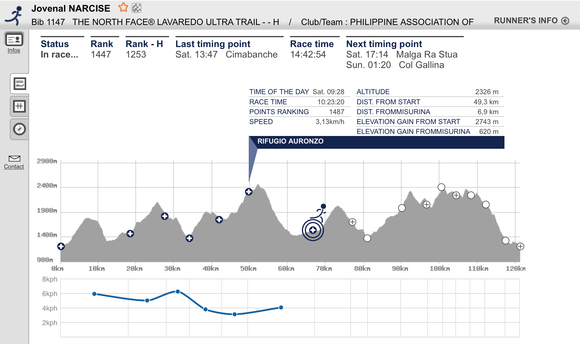
Rifuego Di Auronzo
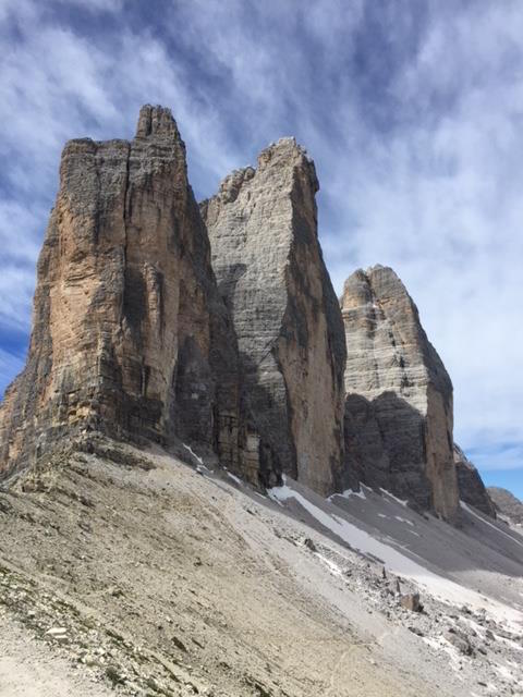
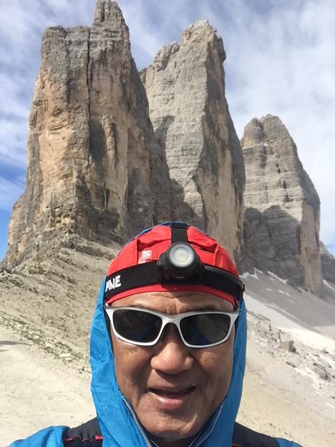
From the paved road, I veered right from the highway and followed a single-track trail that seemed to be going flat and downhill but it was a short one. Looking up ahead of me, I could see from the distance, the iconic Rifuego Di Auronzo where the famous 3-rock mountain formation is located! The Tri Cime mountain formation is the LOGO of the TNF Lavaredo! By looking at the next Aid Station at the Tri Cime, I had a mixed feeling of delight and sadness as I need a lot of strength to reach the highest point of the course. The single track trail was a relentless uphill climb which is about 2-3 kilometers of steep winding uphill assault. As I was about to crest the last “false” peak, I stopped and ate two packs of Skyflakes Condensada and followed it with a Clif Power Gel. I was able to regain my strength after that and I was able to reach the Aid Station and Cut-Off Time Checkpoint at Rifugio Di Auronzo in 10:23 hours! I was able to accumulate a buffer time of almost one hour at this point.
It was an awesome sight to see the Tri Cime in Lavaredo, Dolomites and I became in love with the place! But before I could absorb what I was seeing and feeling at that moment in a place so beautiful to be at, I need to refill my bottles and ate some pasta soup with powdered cheese at the Aid Station. I was seated beside an Indonesian runner and we had a short conversation. The Indonesian happened to be in the same hotel where I was staying and he arrived later than me in Cortina. He is 54 years old and he looks like he is from their uniformed services. I think I was able to spend at least 15-20 minutes in this Aid Station. Finally, The Indonesian and I left the Aid Station at the same time. However, he was stronger and faster than me in hiking with his trekking poles.
Tip: Never, never, never stay at the Aid Station for more than 5 minutes if you need to eat and rest thereat.Never have the temptation to sit!
It was a flat downhill wide dirt road from the Aid Station which is about one and half kilometer and we had at least 3 kilometers more of uphill climb to reach the peak of the Lavaredo Mountain which is the highest point of the course. I could still keep in step with the Indonesian guy on the first 1.5 kilometers but when we turned left for the steep uphill climb, he made a considerable distance from me but I could still see him from afar. I think I was able to reach the highest point in almost one hour from the Aid Station. I think it was at this point where I was able to meet the Official Photographers of the Event. It was also at this point that at least 3 local runners, coming from behind me, tapped my shoulders and cheered me & congratulated me for reaching the said place!
Peak of Lavaredo Mountain
Finally, I reached the peak of the Lavaredo Mountain where I could see the North side face of the Tri Cime! As I hiked the first few meters going downhill, I was excited and happy to have reached at this point. Since my Garmin GPS Watch had been connected with my USB Charger, I could not see what was my actual distance at this point but on the Map/Elevation Profile as reference, it could be at Km 51.
After hiking downhill for about 250 meters, I started to feel dizzy. The feeling was like I was drunk with Irish Whiskey and became sleepy! It was almost 10:00 AM (actual day time) and the weather was mild (but I was still wearing my Patagonia Windbreaker with the hood on my head). I panicked and I had to rest and lean on right side of the trail/dirt road. The left edge of the road is deep ravine. While resting and taking in some deep breath, I was tempted to bring out my cellphone and took the picture of the Tri Cime. After taking the picture and drinking some sip of my electrolytes, I resumed my hiking! However, after another 100 meters, I felt some dizziness again! Instead of stopping, I reduced my pace and went nearer to the right side of the trail just to anticipate that if I fell to the ground or pass out due to dizziness, I will not fall to the ravine. I became nervous as I hiked with the thought that I might pass out at this place and be air-lifted with a helicopter or just pass out to die while I am on this place of the earth. All of these things were in my mind, trying to figure out what could be the best to do in this kind of situation. I guess, a simple prayer did the trick and more deep breathing to remove the feeling of dizziness while I was hiking slowly towards the first switchback of the downhill course!
Tip: If you think something is wrong with your body, STOP, take a rest, relax, take a deep breath, and enjoy the scenery. Re-assess yourself, PRAY and resume slowly.
The first switchback along this downhill course from the Tri Cime/Peak of Lavaredo is being guarded by Park Ranger or Polize (?) who were in Red Uniform. From this switchback, it was a steep, rocky and very technical single-track trail which is about 2-3 kilometers of more switchbacks. As I hiked and jogged this portion, I started to feel some pain on my left knee and my quads were already feeling to had been trashed. As I crossed a dry river bed on the bottom part of this trail, I could hardly lift my legs and my left knee pain became more painful. I tried to hike on the flatter section with my trekking poles to relieve the pain on my knees and rest my trashed quads.
I could feel already the warm air on the lower elevation of the course and I started to have some sweat/perspiration and tried to lessen my thoughts about my left knee pain. I did not remove my Patagonia Windbreaker and instead, just removed the hood from my head and I could still feel the cold breeze passing on my head.
Landro To Cimabanche
Finally, I was on the last 3 kilometers before the Aid Station/Cut-Off Time Checkpoint at Cimabanche (Km 66.9) and I started to do whatever “speed drills” and “strides” I did in my training in order to speed up my pace. The wide dirt road seemed to be flat but in reality, it is a gradual uphill climb up to the Checkpoint. I tried to do all my best to reach the Aid Station within the cut-off time in 12:30 hours but I was thinking already that my race was done once I reach at this point. My aching left knee could no longer withstand the next 53 kilometers of more challenging climbs and steep descents, thus, I could no longer accumulate some buffer time in every Checkpoint. I was envious of those local Italians who were cycling on this road with their nice jerseys and expensive Mountain Bikes, as they would pass or meet me along this road. I just entertained myself on looking on these young men and ladies biking on the said road.
The “sweepers” were able to reach and catch me on the last 50 meters before the Aid Station. One of the sweepers started a conversation with me after he saw on my Race Bib that I came from the Philippines. He told me that his wife is a Filipino and she is from Digos City, Davao Del Sur and they have some children (I forgot how many) and he showed me the pictures of his wife and children in his cellphone while we were jogging. He even asked with a “selfie” with me! Wow! These Italians are like Filipinos and they like/love Filipinos!
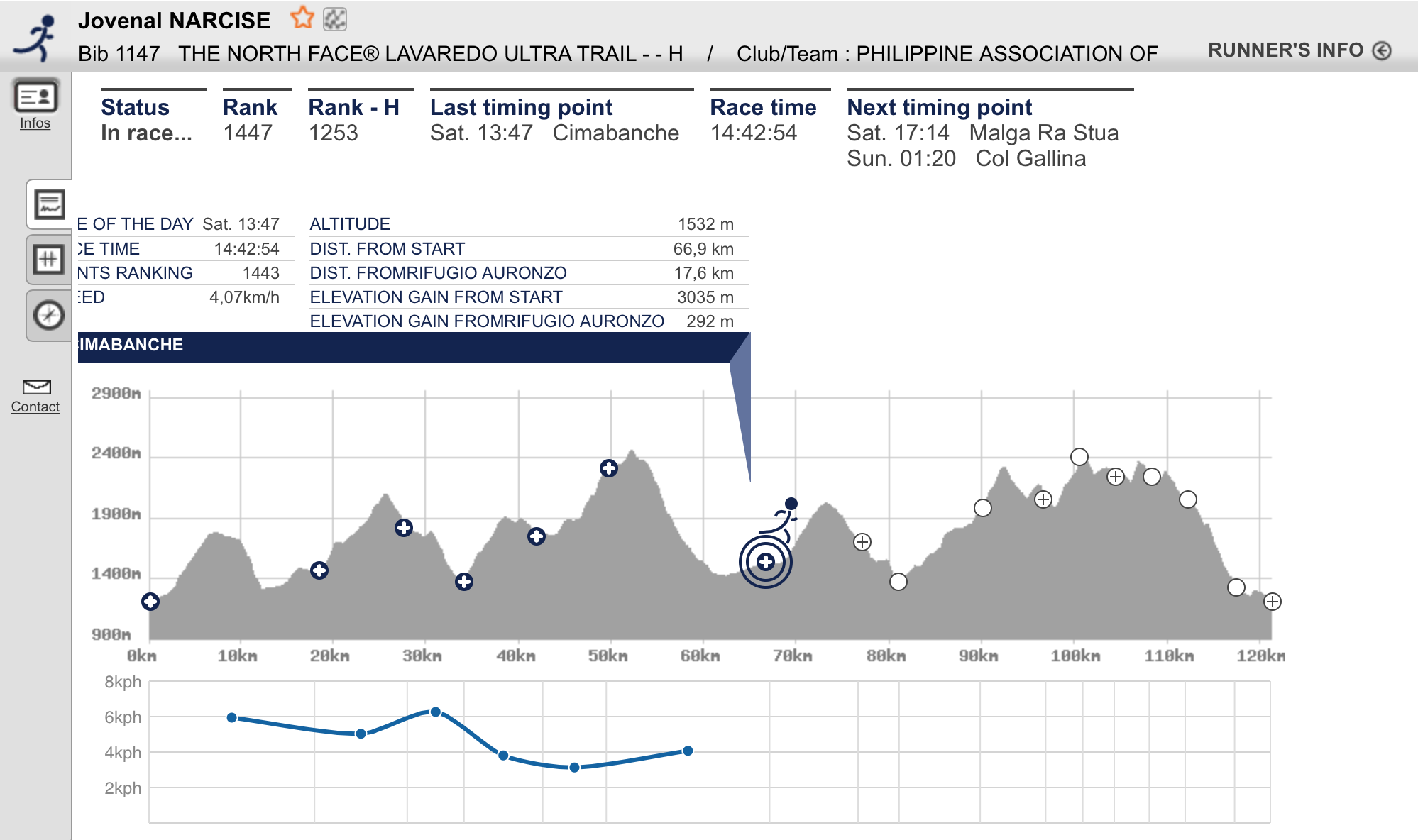
I missed the cut-off time by almost 13 minutes!
Tip: Listen to your body…always! Determine your limits and gracefully surrender in defeat. There will always be next time to redeem yourself. You can not fight against nature if you are already weak and injured. You will never win!
While we were in the bus going back to the Ice Olympic Stadium in Cortina, I counted the number of runners who DNFd in the Aid Station and I was able to count to 12 and I was the oldest, I think. I just smiled and one the ladies (from Croatia or Poland?) in the bus (who smiled and winked at me in one of the previous Aid Stations, I guess, in Rifugio Di Auronzo) was also there and she smiled at me, too before I was able to sleep during the ride!
To be continued…
