The race starts inside the Bataan Death March Shrine/Park in Mariveles, Bataan. From the fenced Park/Shrine, runners will exit from the Gate and turn right towards the Highway going to the Poblacion of Mariveles, Bataan.
Bataan Death March Shrine In Mariveles, Bataan
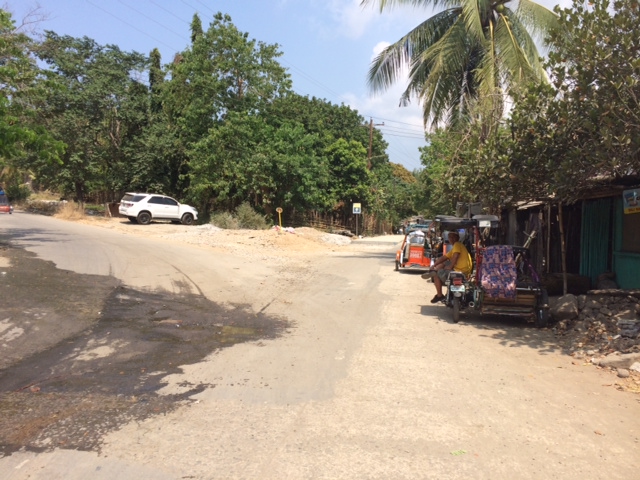
Runners will go straight along the Highway with the Jollibee and the Municipal Hall of Mariveles on the right and the sea on the left. Runners will run on the street along the sea until they will reach Ricarte Street. Runners must turn LEFT on Ricarte Street, staying on the Left Side of the road.
Kilometer #1Ricarte Street , Then Turn Left
While on Ricarte Street, go North until one has to turn RIGHT towards Barangay San Isidro.
Turn Right On This Road
At the end of the Road along Barangay San Isidro, there is a Bridge that is under construction. It is either you follow the Detour or pass in between the Blue Tarp Fence.
Bridge Under Construction
The picture below shows the road after crossing the Bridge under construction. Take the road on the right which has a Camaya Coast Directional Sign seen on the Left Side of the road.
After The Bridge, Keep Right
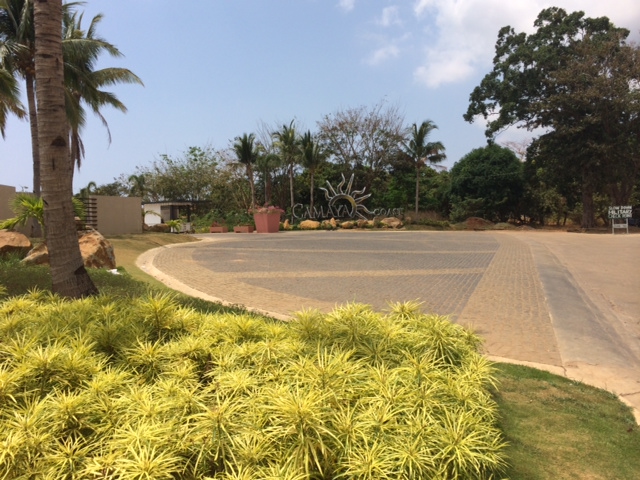
Follow the Camaya Coast Directional Sign up to the Gate of the Resort. The distance from the BDM Park/Shrine to the Gate of the Camaya Coast is 14 Kilometers.
Follow The Camaya Coast SignCamaya Coast Gate Keep Right
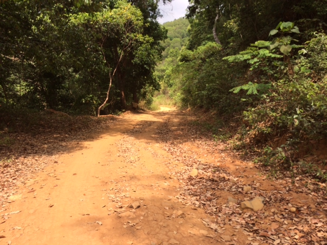
Once the runner reaches the Gate of the Camaya Coast, turn RIGHT after the CAFGU/PA Detachment which is located on the RIGHT of the Road. The entry to the wide dirt trail road will be descending and the dirt road road has a distance of 12-13 kilometres.
1st Kilometer Of TrailAt Kilometer 2-3 Along The Trail Road
There will be intersections along the trail portion of the route but there is ONLY ONE Thing to remember—ALWAYS TURN RIGHT!
First Intersection Keep Right
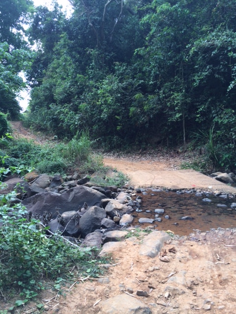
There are at least two river/stream crossings along the route. One is not too deep but the other one is waist-deep when one has the intention to make a dip into the river. One can cross both streams without ones shoes being wet.
First Stream Crossing
After the first stream crossing, there is an intersection and one has to TURN RIGHT towards the direction of Bagac.
Second Intersection, Keep RightThe View
Some parts of the wide dirt road are under construction and I can predict that this route will be all paved by next year!
Dusty Road Under Construction
The picture below is the 2nd stream/river to cross but there are already culverts in placed along the flow of the river making us to cross the river with dry feet/shoes.
2nd Stream/River Crossing
This is the first Kilometer Post that one can see after passing the wide dirt road and it tells that the distance to Bagac is 10 kilometers.
Km Post 161
If ever you reach this Bataan Death March (BDM) Kilometer Post in Bagac, it means that you covered a distance of 45 Kilometers. One has to pass this Kilometer Post towards the Phil-Japan Friendship Tower and reach the 2nd BDM Post along the Bagac-Pilar Highway from the BDM Km Post 00 and then turn-around back to this BDM Km Post for the Finish.
Finish Line
There will be two (2) Aid Stations along the route. The first Aid Station will be positioned at the CAFGU/PA Detachment (in front of the Camaya Coast Gate) and the 2nd Aid Station will be located at the DPWH Kilometer Post #161, 10 Kilometers away before reaching Bagac, Bataan.
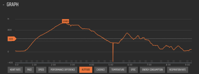
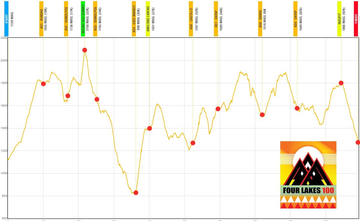
Elevation Profile From Km 0 To Km 45
As shown in the Elevation Profile, the highest elevation is located at the Gate of the Camaya Coast Resort. From there, everything will be descending with some rolling hills up to the Finish Line.
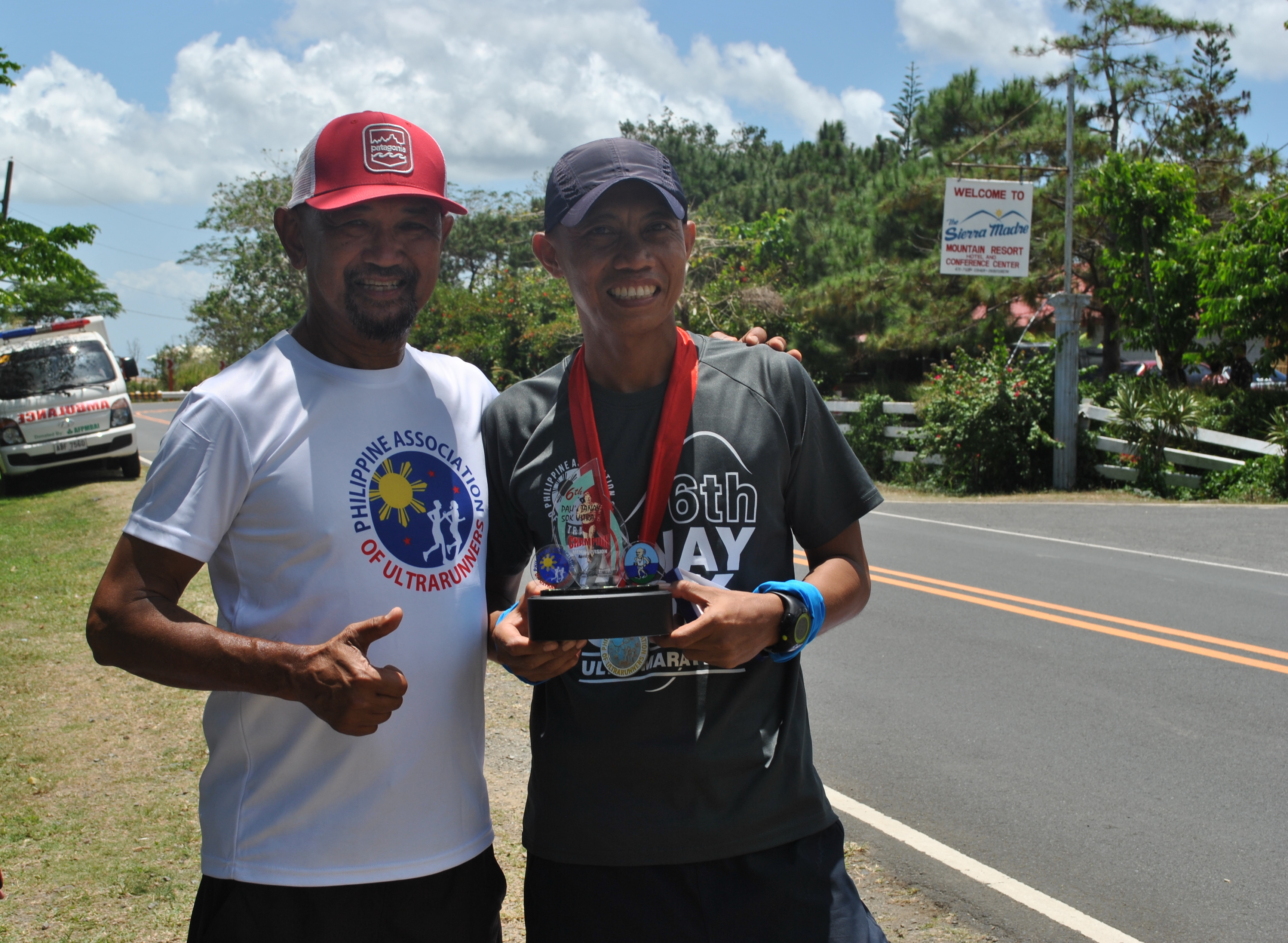
In about one month, I will turn to a 64-year old mountain trail runner and I have accepted the reality that I am getting old and about to retire from ultra mountain trail running with the hope to leave some legacy to the next generation of runners, most especially to the local ultra runners. I also accepted the fact that I am becoming the “cut-off time chaser” in all my past international ultra races. But for the past months, I improved on my nutrition strategy; more rest and recovery in my training; and getting smarter during races. And because of these reasons, I became more confident to finish the ultra races that I intended or scheduled to join this year. I guess, I might not retire in the near future after all.
I was surprised with my performance in last month’s Translantau 100K in Hongkong even if I was stopped at Km 90 due to severe weather conditions in the mountains. If only the race was not stopped by the Race Organizer, I would have improved my previous finish time last year by one hour or more. Instead of earning 3 UTMB Points, all of us who were stopped along the course were considered as Official Finishers and were given 2 UTMB Points. Due to this setback to earn 9 UTMB Points in 3 Ultra Races, I decided to join the 2016 KOTM’s Four Lakes 100K (FL 100) Trail Run and earn 3 UTMB Points from it.
Here are the reasons why I did good in this race:
More Time To Recover & Rest—-The Translantau 90K that I’ve finished 2 weeks before the FL 100, became my “peak LSD” in preparation for the said race. And the last 50K LSD “heat training” that I did one week before the race was my taper run. Within those two weeks, I did two sessions of leg workouts and the rest were devoted to rest and more sleep. However, before the Translantau 100, I finished the Condura Skyway Marathon (42K) and my Fort Magsaysay To Dingalan 65K Ultra Marathon Race.
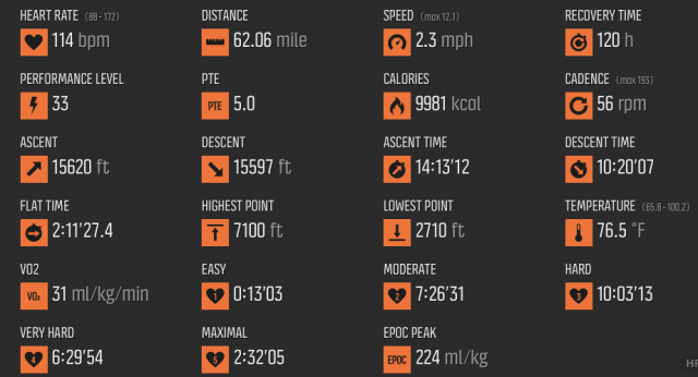
Total Elevation Gain——As a mountain trail runner, this is the most important factor to consider in one’s training and looking at the data gathered and recorded by my Suunto Ambit 3 Peak GPS Watch, I was able to satisfy the suggested Total Elevation Gain that I have to attain within a certain distance. For example, if the 100K trail course has a total elevation gain of 15,000 feet, one must be able to train in a course that has at least, a total elevation gain of 1.500 feet within a distance of 10 Kilometers, 3,000 feet in 20 Kilometers, and so on. My playground offers a Total Elevation Gain of 2,100 feet within a distance of 8 kilometers and if I extend it to 22 kilometers, I would attain a total elevation gain of 4,250 feet! This explains why I have the endurance to go up to the peak of any mountain during races.
Four Lakes 100 Elevation Profile From SUUNTO Ambit 3 Peak GPS Watch
Nutrition & Hydration Strategy——Don’t wait till you feel you are hungry or thirsty that you start ingesting your food or drink your water/hydration mix. To be safe, once my GPS Watch beeps to register that I have completed ONE MILE (1.6 Kilometers), it usually reminds that I have to eat a bite food or drink my hydration mix. If I have an average speed of 3 miles per hour, then I would hear 3 beeps within the hour which means that I ingest any solid food and drink my water 3 times within the hour. Drinking and Eating are done while on the move which I usually do during my training runs.
Train Heavy, Race Light——I usually bring a lot of water during my training runs but in my races, I only carry enough water to sustain me in between the Aid Stations. But I carry my CarboPro mix packs which I programmed to sustain me for the whole course in my pack. For this race, I carried 12 packs (1 pack/serving in every two hours of running/hiking) but in the end, I only used 7 packs for the whole course. The pack that I carried during the which consisted of the mandatory kits and extra solid foods which was lighter in weight than the pack that I carry in my training runs.
Running Kit——The ASICS Running Shorts that I’ve been using in my ultra trail races since last year’s CM50 is becoming my favourite and my best running shorts so far. The ALTRA Superior 2.0 which I used in Translantau 100 is becoming my favourite choice for my 100K trail races, too! My Salomon 5-liter Advance Skin 3 Pack with its accessible pockets had been also helpful that I could easily reach for my bite foods and candies while on the move. My reliable PETZL Tikka XP which is very light gave me more confidence to run during nighttime.
Reduction of Stop Time in the Aid Stations——It would have been smarter not to stay long in the Aid Stations but I committed some mistakes in having unnecessary “long breaks” in between Aid Stations to sit and eat my food. My experience in the FL 100 taught me some lessons and with the hope to improve on them in my next races.
SUUNTO Ambit 3 Peak Data
Looking at the data that had been recorded by my SUUNTO Ambit 3 Peak GPS Watch, I will have to improve on my average pace by eliminating some of the mistakes that I’ve committed in this race. I think I brought so many CarboPro Packs and bite foods in my pack. My lack of knowledge on the route from East Market Proper to Dayap made me slower during the race. I think I was also overdressed when the heat of the sun was at its strongest along this part of the route. Hopefully, I will be able to correct all these mistakes on my next race!
I really did not have any plans of joining the Four Lakes 100K (FL 100) or the Old Spanish Trail 50K (OST 50) this year but with what happened at the Translantau 100K Trail Run in Hongkong two weeks ago where the race was stopped when almost all the runners were at the last one-fourth of the race due to strong winds in the mountains, I finally sent a personal message to my good friend and Race Director of the KOTM Races, Jonel Mendoza, that I would be glad if he will accept my late registration for the Four Lakes 100 Mountain Trail Run. When both Race Directors of Ultra Events in the country talk to one another, the results are always positive.
Within the two weeks in between the Translantau 100 and the Four Lakes 100, I did two sessions of workouts for my leg muscles concentrating on my adductors, the muscle that stretches from the groin to the knee on the inside portion of the leg. I had some experiences of cramping on this muscle during last year’s CM50 and at the Translantau 100 and I need to strengthen and stretched them. I also did one LSD run covering a distance of 50K in a mixed paved and trail surfaces under the heat of the sun one week before the race.
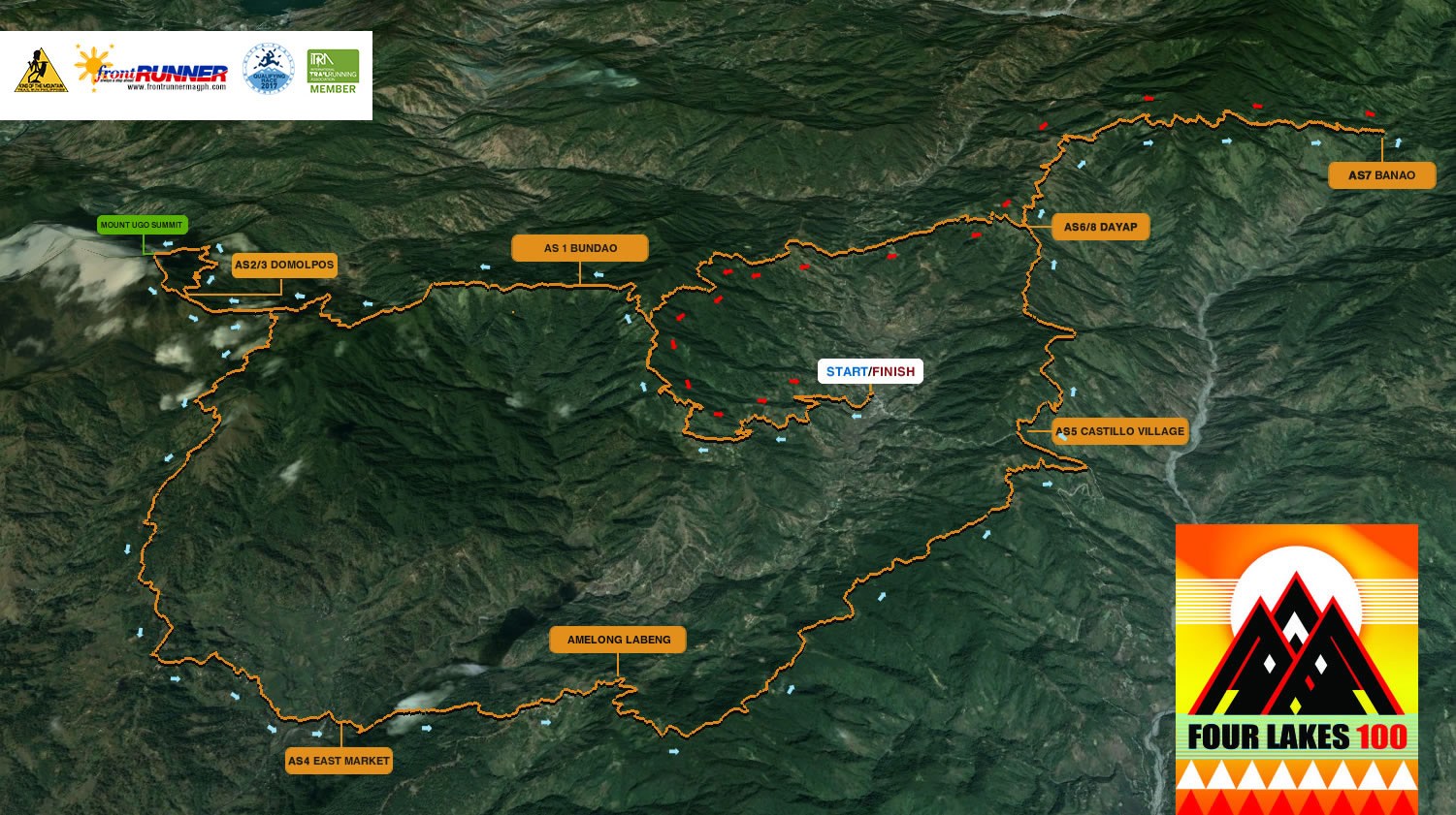
Four Lakes 100K Mountain Trail Run Course Map
There was no pressure or stress on my part what to really expect with this mountain trail race. It will be enough that I would see Jonel and Connie again after years (I think, two years!) of not seeing each other; visit Kayapa and its mountains; mingle with old and new friends who have passion in trail running (most especially in ultra trail running); finally meet my Facebook Friends in person; and be able to earn 3 UTMB points for finishing this race within the cut-off time of 28 hours.
Having finished the first edition of the Mt Ugo Trail Marathon and been a part of the laying out of the Hardcore 100-Mile Mountain Trail Run’s Route Course and a former participant of this race, the Old Spanish Trail (OST) Course is new to me! I have been hearing stories about the place called “Amelong Labeng” from other runners who finished the OST and Four Lakes 100 (FL100) for the past editions but I’ve never asked the details about this place. Since I could not find a detailed description or Race Report of the OST and FL 100 on the Internet, maybe, I will be the one who will try to come up with a good description about the said place through a Race Report on the FL 100.
Race Briefing
Due to a big gathering or event among the locals of Kayapa and neighbouring towns/barangays in the area, the Covered Court of the Kayapa Elementary School was not available and the Race Briefing was moved to the Kayapa Parish Hall which is one of the concrete structures inside the Kayapa Catholic Church Compound. The Hall was filled with lots of trail runners and the rest of the runners who could not squeeze inside the hall were seen standing outside. This was an indication that more runners are interested to join the KOTM series and to think that some of the runners were still on their way to Kayapa, coming from Metro Manila and other provinces.
There are detailed things which are very important that you can not see or read in the event’s website like the description/color of the trail markings or emergency contact number of the RD or being able to see in person and be able to talk with the with the Race Director. Except for the Ultra Events that I’ve joined in Hongkong, the Race Directors in all the other Ultra Events here in the country and in the US are there in person to brief the participants on the “nitty-gritty” of the race event.
Four Lakes 100 Elevation Profile
Since I have made my homework on the details of the event (except for the specific drinks and food to expect in the different Aid Stations) what caught my attention is the steady increase in the number of trail runners in the country based from the “new” faces that I’ve seen during the briefing. I felt like I was the “stranger” among the flock of trail runners and mountaineers present in the hall. There were also foreigners present in the briefing which is an indication that our trail running in the country has attracted them to visit the country.
What I like about the KOTM series is that there is NO fun fare and does not carry any CORPORATE Brand and every runner gets what is worth for what he/she pays for the registration fee. On the other hand, I can see some economic changes as shown from new building constructions at the Town Proper area. This proves that Sports Tourism through the KOTM series is bringing some good economic opportunities for the community.
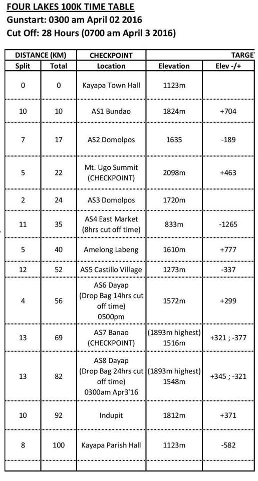
Location of Aid Stations/Checkpoints & Cut-Off Times
Race Proper
Start (Kayapa Parish Hall) To Mt Ugo Peak (Km 0 to Km 22)
In all the KOTM series of race that I have joined, the area in front of the Kayapa Municipal Hall was always the Starting/Assembly Area. And for the Finish at the Covered Court of the Kayapa Elementary School. For this year, the Start/Finish Area was changed to the Kayapa Parish Church Area.
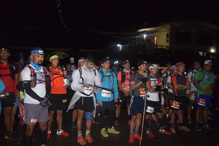
I was already in the Starting Area one hour before the start of the race (2:00 AM of Saturday, April 2) and was trying to see the faces of the runners. Hot coffee, local foods, and water were available in the area. I had myself checked-in with the Race Staff and the RD himself and I was confident that I will finish the race. Some runners would approach me and greet me and it made me more relaxed. I would also greet the other runners as the start will be simultaneous with both of the races, Old Spanish Trail 50K Run and the Four Lakes 100K Trail Run. It was still dark to be able to clearly distinguish which one was running what race as seen from the runner’s race bib. I estimated that we were about 300 runners assembled at the Starting Area and for me, it was already a huge crowd.
Before the customary final briefing of the RD, I mentally reviewed the “plan” that I have formulated to be able to finish the race and forced my mind to strictly follow it. Some of the details of my “plan” were the following: (1) Arrive at the Checkpoints, at least, 2 hours before the cut-off time; (2) Refill my hydration bottles in every Aid Station to mix my CarboPro; (3) Eat my solid food stashed in my pack every hour while moving; (4) Don’t stay more than 2 minutes in the Aid Stations; (5) Hike the Uphills and Force myself to run on the flats and downhills; (6) No picture-taking/“selfies” using my iPhone; and (7) Never miss to place a “Coffee Candy” inside my mouth!
Invocation/Prayer Before The Start Of The Race
At exactly 3:00 AM, the race started after a countdown from 20 to GO! I started with an easy jog as the first 100 meters was downhill and I could feel that the first 1 kilometre of the course was runnable until the road started to ascend. The first 3 kilometres are already paved as compared few years back that it was only a paved tire track then with patches of dirt road. At the start of the 4K mark, I started to feel that I was already perspiring and it was time for me to unleash the trekking poles tied on my hydration pack. Since the first 10K of the course is uphill, I maintained my hiking using my trekking poles as a support for my old knees and legs! It was still too dark and I was not keen of knowing where and what are the things that I could see around me. I just concentrated on seeing on what my headlight would illuminate…and that is—one meter ahead of me! There are times also that I would bring up my head and see what is happening above me as we snaked towards the higher grounds of the mountain. It was nice to see the headlights of the different runners going to the peak of the mountain.
Approaching AS2 In Domolpos
After two hours of continuous hiking, I reached Barangay Indupit and the surroundings was starting to get brighter as the sun was about to rise on the eastern horizon and at this point I was about to cover a distance of 10 kilometres. Ahead of me was the towering sight of Mt Ugo and the tiny dots of different colours of the runners’ shirts ahead of me as they approached higher elevation. It was a sight that motivated me hike or jog faster along the course.
I started to run when I would see that the trail is descending and without much effort I would be able to increase my pace. From Indupit to Domolpos was an easy run and I reached the Aid Station after 3 hours from the start. I immediately refilled my hydration bottles and prepared my next mix of CarboPro. In a short time, I was ready to “assault” the peak of Mt Ugo. At this point, I started to see the faster runner coming from the peak of the mountain. I would give way and stepped aside from the trail for the runners coming from the peak. This is where I was able to find out that there are so many trail runners whom I don’t know their names! Slowly but surely, I would be able to reach the peak of Mt Ugo in almost 5 hours but I was still comfortable to make up for my slow ascent to the peak after leaving the mountain.
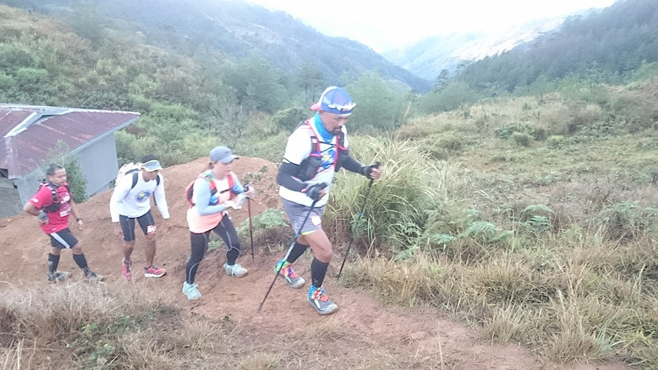
Running With The Ladies Along The Course (@Assault To Mt Ugo)
I ate my breakfast at the peak of Mt Ugo and had some picture-taking with a group of friends which slightly delayed my stay at the said Checkpoint. It was nice to finally see the faces of the runners as the day was becoming brighter. Looking at my watch, I was able to register and cover a distance of 14 miles or 22 kilometres!
Mt Ugo Peak To Kayapa East Market (Km 22 to 35)
It was a breeze to go down from the peak of Mt Ugo but with those small rocks along the trail and slow lady runners ahead of me, I was very careful and deliberate in every step of the way. In about 30 minutes, I was able to reach the Aid Station in Domolpos. I immediately filled up my two Simple Hydration Bottles with water and CarboPro mix and be ready for the long descent to the Kayapa East Proper Market.
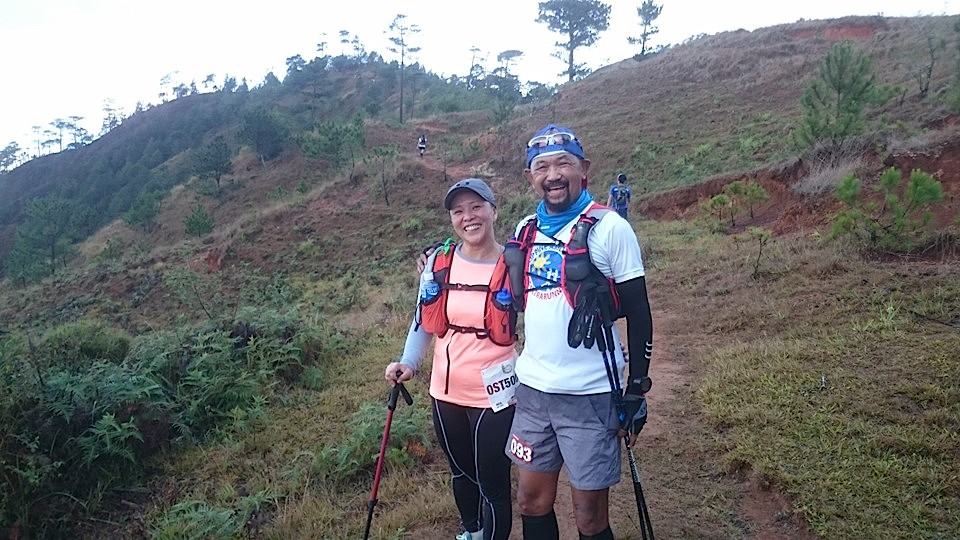
@ Mt Ugo Peak With Team Tarayem
Since the trail is descending as seen from the course elevation profile, it seems to be easy but with the nature of the trail as being rocky and single track, there is some difficulty in passing the slower runners ahead of me. The trail on this part of the course could be described as very dangerous for very fast runners that a single misstep will lead them to fall on the ravine on his right or hit the rocks on the side of the mountain on his left side.
In my estimate, I was able to reach the AS4 at the Kayapa East Market in 7 hours with one hour as buffer time before the cut-off time of 8 hours in this place. I stopped to refill my bottles and eat some solid foods. I was craving for an Ice Cold Coke but the AS did not have any and one of my good friends assisting in the said AS readily produced a 1.5-liter of Coke. He even gave me a bagful of assorted fresh fruit bites with ice inside the bag and and a bowl of rice porridge with two hard boiled eggs. It took me about 10-12 minutes to sit, rest and eat the foods served to me.
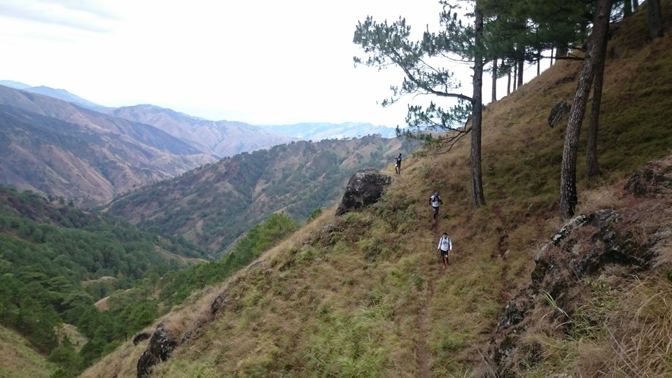
Tiny Dot Along The Old Spanish Trail
Kayapa East Market To Amelong Labeng (Km 35 to 40)
As I left the Aid Station/Checkpoint, I knew already what to expect for the next miles—I have to reach the peak of the next mountain with those Telecommunication Antenna! As I was crossing the hanging bridge to the foot of the mountain for the start to my trek to Amelong Labeng, I was reminded on those other hanging bridges along the Hardcore 100-Mile course that one has to cross. Slowly, I was going up to the mountain with the aid of my trekking poles but the heat of the day was making it more difficult for me to have a faster pace. I would take a number of short rests for about 5 seconds each pause before going up again to the said mountain. On hindsight, I committed a mistake in resting in a waiting shed with the rest of the runners where the conversation among us ate most of our time not knowing that most of the runners in the waiting shed were with the shorter OST 50K Race. But the said rest gave me time to eat and hydrate and was able to meet some friends on Facebook whom I met personally for the first time. When my friend Bong Bernadez came up to rest in the Waiting Shed, he gave us the news about the new cut-off time at AS6 in Dayap. I thought it was 14 hours but it was changed to 16 hours! But there is no need to relax as I was focused to finish the race and earn more buffer time in each AS or Checkpoint!
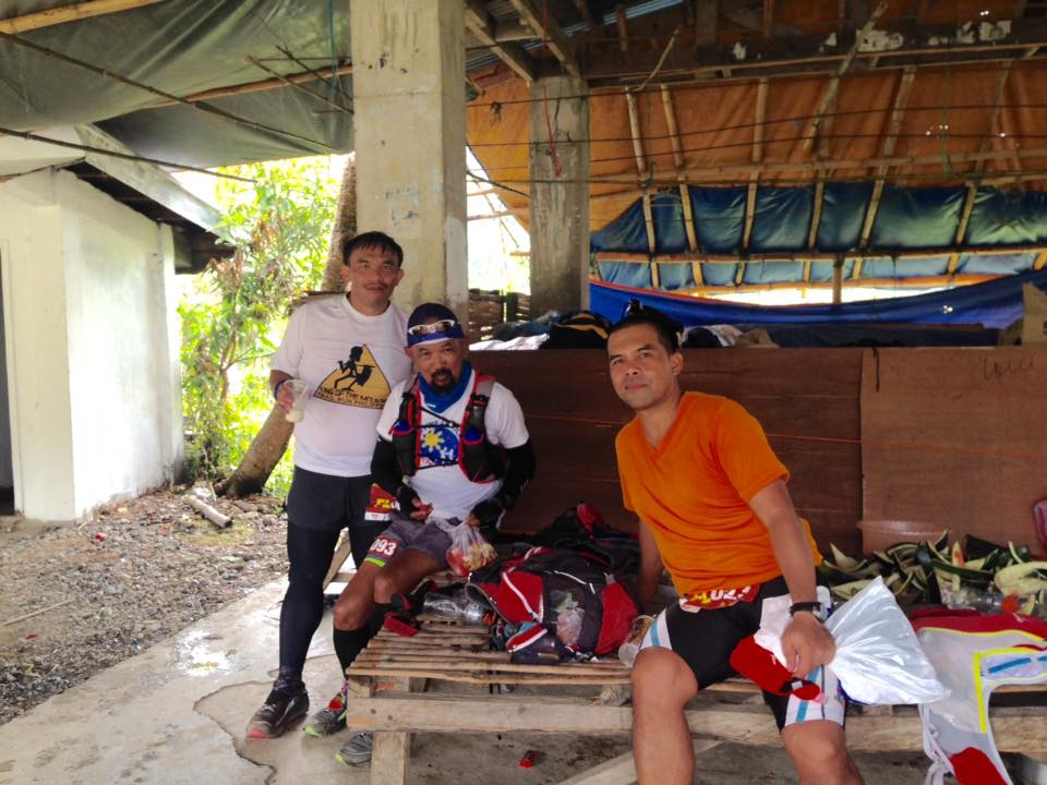
@AS4 East Kayapa Market (With Bong Bernadez in Red Shirt)
Amelong Labeng To Castillo Village (Km 40 to 52)
The steep ascent to Amelong Labeng stopped when we reached a school where I managed to refill my bottles in a Comfort Room. I took some time to douse the cold water coming from the faucet to my head and neck. I was comforted with the cold water and I was ready again to reach the next peak where the Transmission Antenna are located. I did not have any problems with my stomach or my leg muscles at this point but the heat of the sun was my main enemy at this point. It was good that I had my last LSD “heat training” a week before the race that I braved to jog and run to the peak. Moreso, when I reached the peak, I continuously jogged and hiked from the peak of the mountain up to the time that I reached the Aritao-Kayapa Highway. Along this part of the course, I monitored my nutrition intake and closely observed the colour of my urine. I was satisfied that I did not feel or see some signs or symptoms of dehydration. I knew that I was perspiring heavily but with my constant drinking of water and CarboPro…and never-ending supply of Coffee Candy in my mouth, I was confident that I would not be dehydrated because I carried with me an extra Salomon collapsible soft plastic bottle full of CarboPro mix . From Amelong Labeng to the peak of the mountain is runnable as the trail is a wide dirt road and it is the same with that in going down from the peak of the mountain to the Aritao-Kayapa Highway. I was able to regain more of my buffer time within this part of the course.
Castillo Vilage To Barangay Dayap (Km 52 to 56)
I was craving again with a sweet Ice Cold Coke once I reached AS5 in Castillo Village. The Pepsi-Cola Max drinks available in the AS didn’t have any sugar in it but just the same I drank some of it. I did not stay long as soon as I refilled my bottles. It was another long climb again coming from the AS5 and the heat of the sun was at its strongest! It never affected me as I steadily used my trekking poles to reach the higher elevation of the next mountain. Before reaching the “Green Lake”, I stopped to eat “suman”/rice cake wrapped in banana leaves and Pork Chicharon! It was a nice feeling to see the “meadow” at the peak of the mountain after passing the Lake! But it was short-lived when I started to go down from the mountain as the trail was slippery and narrow and the descending nature of the trail gave some pain on my knees! My running friend would jokingly said that down the mountain is the next “Lake” and I was laughing when I saw what he was referring to…it’s a Lake full of carabaos! At least, it was a good diversion and joke to forget my aching knees as went down to the foot of the mountain.
After another ascending road, we finally reached AS6 in Dayap and I reached it in 14:10 hours! After eating a bowl of hot Macaroni Soup, changing my shirt, and refilling my bottles, I was out of the AS6 towards Banao at 14:20 hours or 5:20 PM of Saturday!
Dayap To Banao (Km 56 to 69)
As I left AS6 Dayap, I started to meet those faster runners as they were coming from Banao, the turn-around point at Km 70. It was nice to meet and greet them as it was still clear to see their faces (it was about sunset already after leaving Dayap). I mentally calculated that I have to reach Banao in 3 to 4 hours and be back again to Dayap with the same elapsed time so that I will be able to make it before the cut-off time of 24 hours. With a distance of 13 kilometres for one-way (Dayap to Banao), I was confident that I would make it, not unless I got injured or have some muscle cramping along the way that would slow me down!
Later in the early evening, I would see approaching lights coming from the runners as far down and up in the mountains and it gave me some impression if the trail ahead of me was ascending or descending. If I see lights lower than where I am, I would increase my pace as the trail is descending. If the lights are above me, I would power-hike with the aid of my trekking poles and try keep up with my prevailing pace as shown in my watch. This was repeated as well as greeting the runners that I have to meet along the dark trail.
After 3 hours, I was able to reach AS7 Banao and I was happy to reach the turn-around point with added buffer time. After a taste of the delicious hot misua with pork, I was out of the Aid Station and determined to reach back to Dayap. I gave a brief message of thanks and gratitude to all the people at the AS7 before I left by telling them that they are “the angels who came from heaven who saved me after a lot of fights with the demons along the dark and lonely road from Dayap to Banao”.
Banao To Dayap (Km 69 to 82)
I consider this part of the course as my most challenging segment of the course! I started to feel my lowest level of power and strength after covering 4 kilometres from the Aid Station as the trail was relentlessly and never-ending uphill. This is where I felt hungry, cold, sleepy, and weak! There is only one solution——find a place to have a short rest and eat some solid foods! That was what I did! I even shared some of my food to a runner who stopped in my place just to change the batteries of his headlamp! More coffee candies had to be placed in my mouth and keep on drinking my CarboPro mix! After that brief rest, I was energized and continued my trek/hike towards Dayap. I made it in 3.5 hours! I reached AS8 Dayap in 21:28 hours and then left the place after refilling my bottles after 1-2 minutes. The volunteers were offering some hot macaroni soup but I declined the offer and left the place immediately. At this point, I was able to accumulate 2.5 hours as buffer time fort he whole course’ cut-off time of 28 hours.
Dayap To Indupit (Km 82 to 92)
I am already in a more familiar ground as I was descending from Dayap to Pangawan. Though my old knees were hurting as I ran down on those steep and paved road towards the Kayapa-Ambuklao Highway, I tried to keep up with a faster pace but I conservatively prevented from exerting much effort as I knew I have another last steep uphill to encounter before reaching Indupit. As I reached the Highway, I knew I was already in Pangawan. Slowly, I would power hike on those ascending paved road towards Indupit with lots of “false” peaks along the way. When the paved road ended in one of the peaks, it was time to turn right on a single track grass-covered trail and I was on my way to the “mossy forest”.
I will never forget this “mossy forest” as it was the “culprit” why I was DNFd in my attempt to finish the Hardcore 100-Mile Trail Run two years ago! For this year, it will be remembered at the place where I was hit for three times, yes, three times, on my head from the branches overhead as well as from those fallen trees across the path/trail. This is where one would crawl under fallen trees and be patient on the never-ending single-track trail circling the side of the mountain as if you are not leaving the forest! Runner, once again, should be very careful on this trail because the left side of the trail is a cliff/deep ravine and running along this trail needs a lot of focus and attention! Finally, I heard the voices of the runners who were 30-minutes to one hour ahead of me before reaching the Banao turn-around point and they are starting their their descent to the Finish Line.
Indupit To Finish (Kayapa Parish Hall)
It was 24:55 hours when I started my descent from Indupit to the Finish Line. I had almost 3 hours to cover the distance of 8 kilometres before the cut-off time of 28 hours. I tried to reach the last person among the group of runners ahead of me and passed some of them. But later along the way, I decided to slow down and hiked most of the descending parts of the route. There was no need to race with the rest of the runners ahead of me. I gave them the courtesy to finish the race ahead of me even if I still have the speed and strength to reach and cross the Finish Line with a faster pace. It was time to relax, cool-down, remove and stash my jacket inside my pack, tie my trekking poles to my backpack, turn-off and remove my headlight, and fix my running cap. While hiking down to the Finish Line, I tried to review the things that I went through and already came up with a story for my blog.
I finally crossed the Finish Line at the Kayapa Parish Ground with an unofficial time of 26:45++hours!


You must be logged in to post a comment.