
Race Report: KOTM Marikit-Pigingan 47K Trail Race (First Edition)
The following were the reasons why I joined this trail race: (1) This race is my first trail running event for the Season 2020 and my second trail running event after I renewed my subscription as a CTS athlete since the middle of November last year; (2) This is supposed to be a part of my training in preparation for my 2020 TransLantau 50K participation in Hong Kong as my last Long Run (whether I finish the race or not); and lastly, (3) To confirm and validate my training which was given as a part of my weekly workout—the use of weighted backpack for hiking for at least once a week.
Since the RD of the event is a friend of mine, I sent him a message of my intention of joining the race being the first edition of this event. He was glad that I would be attending this race. In the later days before the race, I asked him of the directions going to the venue as I am not familiar of the other side (eastern) of Itogon, Benguet. Two days before the event, I was able to trace the route going to venue, coming from Baguio City. With the help of a local living in Sitio Dalupirip and working as the Municipal Nurse of Itogon, Benguet, she guided me all the way to the end of the cemented road leading to the populated area of the Sitio. Having seen the overall location of the event, I knew already that the terrain will be challenging as well as the prevailing weather in the area. The place is surrounded with higher mountains and not so much of vegetations on the mountains we will be running, I expect that we will be fighting with the so-called “canyon heat” while we will be running under the heat of the sun.
From The Podium Hotel where I usually stay in Baguio City, it took me at least One Hour drive to Dalupirip, arriving at 2:30 AM of Sunday (Race Day). From the end of the paved road up to the Start/Finish venue (Covered Court), it is a good one-kilometer distance, crossing the river on a cable suspension bridge which is only good for motorcycles and pedestrians with a wide cemented footpath leading to the Covered Court surrounded with rice fields.
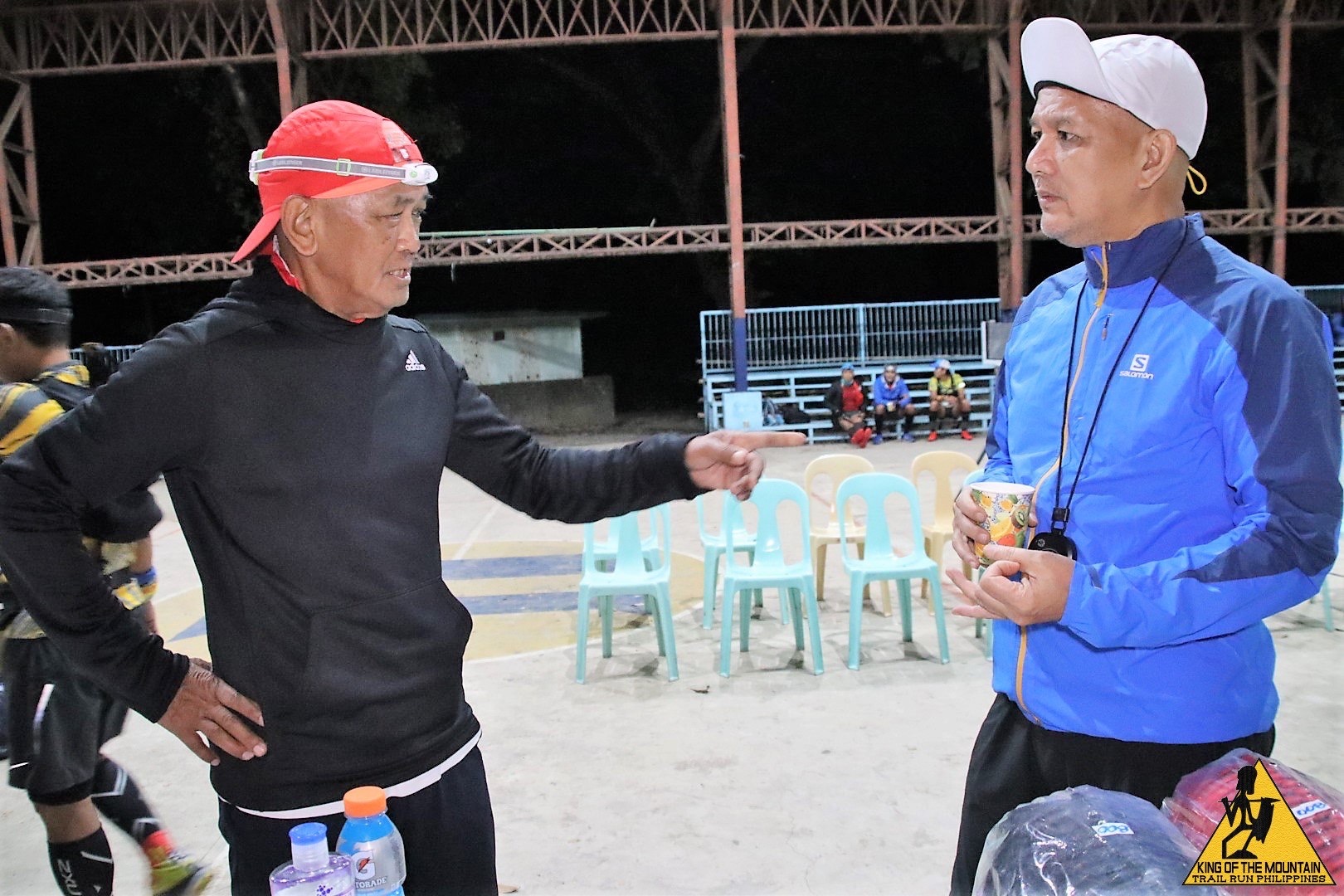
After I registered and checked-in with the RD and staff, I went back to my vehicle to prepare my things. At 3:30 AM, I was back at the Covered Court just in time for the start of the briefing by the RD.
Race Proper/First Loop
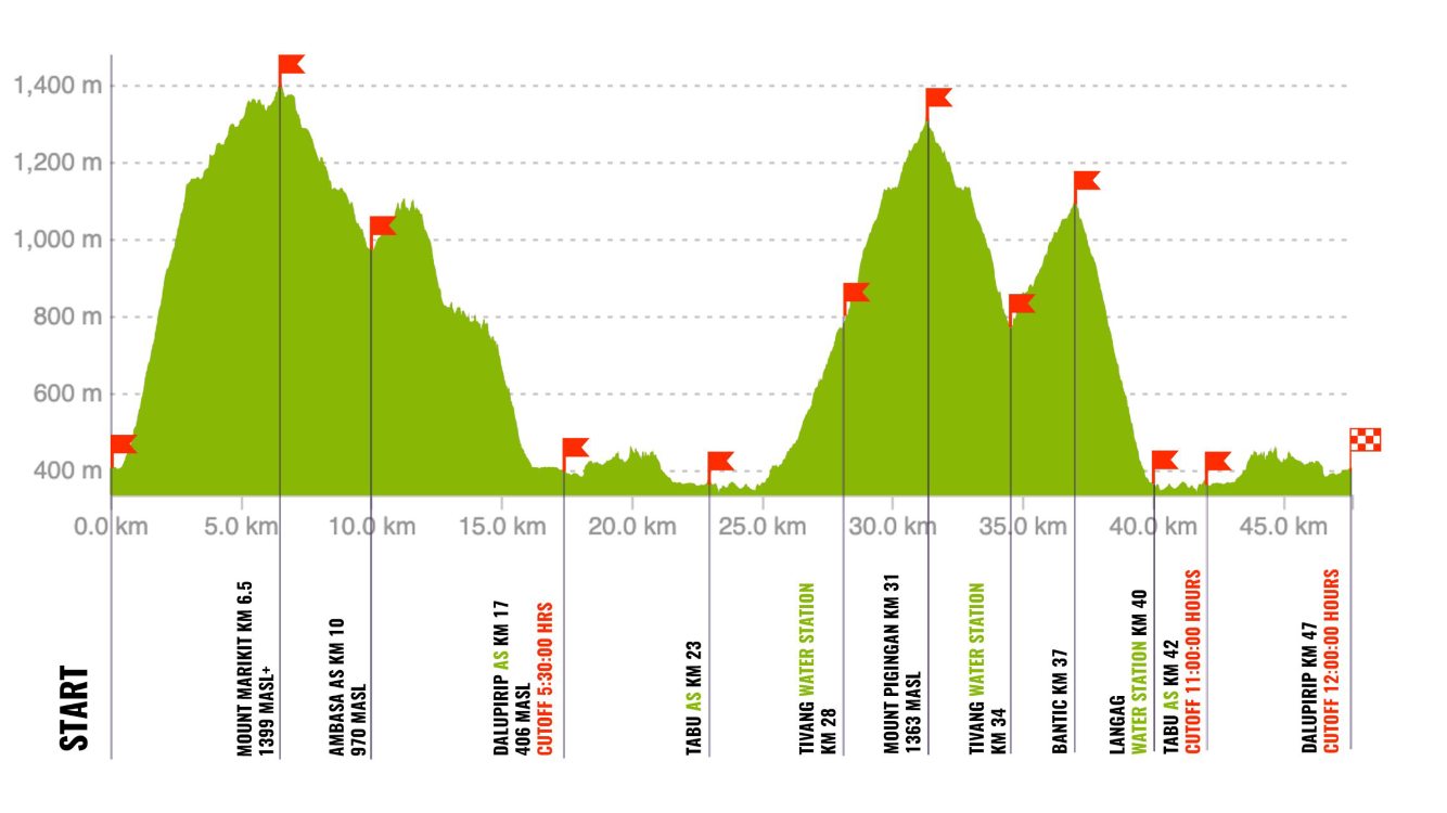
The race started at exactly 4:00 AM and it was still dark and my new Neo Headlamp was on. I positioned myself at the back of the pack, as usual, with the thought to just follow the runner in front of me. The plan was to enjoy the route/event; pass as many as runners along the route and finish within the prescribed cut-off time of 12 hours. On the first kilometer we passed by in-between houses within the Sitio of Dalupirip along a cemented pathway until we reached the road that leads to the Starting Area from the place where I parked my vehicle. We turned right into a paved path and the ascent started and the runners formed a “Conga Line”, a single-file formation going up to the mountain. I think I was able to pass 3 runners at this section and then suddenly the runners in front of me stopped, trying to look for ribbons/markers. The runners argued if we were in the right track or not and some of us “backtracked” to find the last ribbon along the route. At this point, we heard shouts from the Marshals below us and loud sounds from horns of motorcycles indicating that we were in a wrong directions. We were advised to return to the Start Line and follow the proper route on the first 1-2 kilometers as advised by the RD. As I passed the Starting Line (again!), the RD advised me and the other runners that the cut-off time will be 13 hours due to the delay we encountered. As I glanced my watch, almost 40 minutes had elapsed already and I was confident that I could finish this race in less than the new cut-off time.
I was joined by a runner who knows the route and we were together for the first two kilometers until I went ahead of him. Since it was still dark, I hiked slowly in between rice fields until I reached a trail that ascends towards the first mountain of the course. The trail was very steep that I was forced to use my trekking poles. I just contented myself to just follow the lights in front of me and at the middle of the steep trail to the peak of the mountain, I started to pass more runners who went ahead of me. Through consistency and patience in steady hiking with the aid of my trekking poles, I was able to reach the peak of the mountain and it was already early in the morning as the sun rises in the east. I was amazed by the beauty of the mountains around and the river that flows at the feet of the mountains. It was a relief to hike and run on the flatter portions of the mountain until I reached the first Aid Station. I refilled my water bottles and ate a bite of sandwich and I was joined by two runners, Elle Alvarez and a guy, in the said Aid Station. Loiue Ganayan told me that I am ranked #30 runner to reach the said Aid Station. I left the Aid Station ahead of the two runners and I observed that the trail follows a water canal until I descended in the said mountain. However, in one of steep descents, Elle Alvarez was behind me calling me “General” and asked if she can pass me so that she can have some time to pee at the bottom of the mountain. It was the last time I saw her. In about one hour from the Ambasa Aid Station (Km 10), I was already on my way back to the starting area to complete the first loop/mountain which is called Mt Marikit.

Second Loop
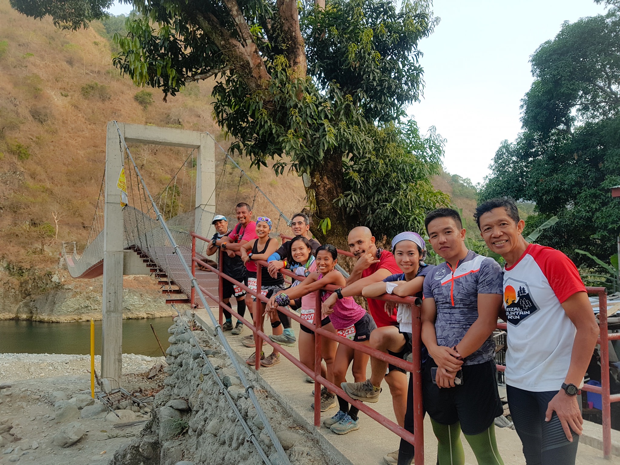
I think I was ahead of more than one hour with the prescribed cut-off time at this point. At the Dalupirip AS/Start/Finish area (Km 17), I refilled my hydration bottles and immediately left the area. I started to hike and run as the first 2 kilometers was flat until I reached a long hanging cable bridge. I brought out my sunglasses from my pack as I could feel that the sunlight was getting brighter and the air was becoming warmer. My friend Bong Bernadez was at the cable bridge as he was taking pictures to all the runners crossing the said bridge.
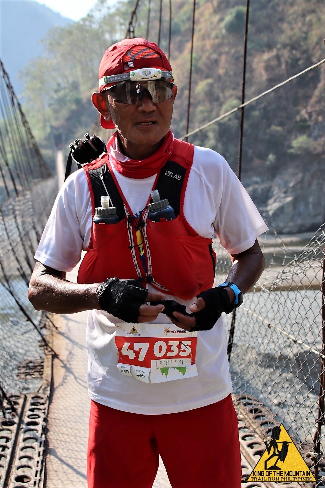
The road was still concrete as I followed the path in between rice fields and some populated areas along the route. As I left the populated area and the rice fields, I just followed a concrete road until I reached another end of a long cable bridge on the side of Dalupirip which looks very new and more modern and I was at the Tabu Aid Station. I refilled my hydration bottles, drank a glass of Coke, and ate two slices of rice cake before leaving the place. After crossing the cable bridge, the route became a wide dirt road which have slight ups and downs and at this point I was following a lady runner who was steadily hiking with her trekking poles. After two kilometers, the ascent was continuous and started to feel the heat in the said place. It was good there were small pipes and strips of bamboo connected to the side of the mountain where potable water was flowing. I took some time to douse my head with the cold water but after a few meters of hike and run, I would feel again the heat on my body.
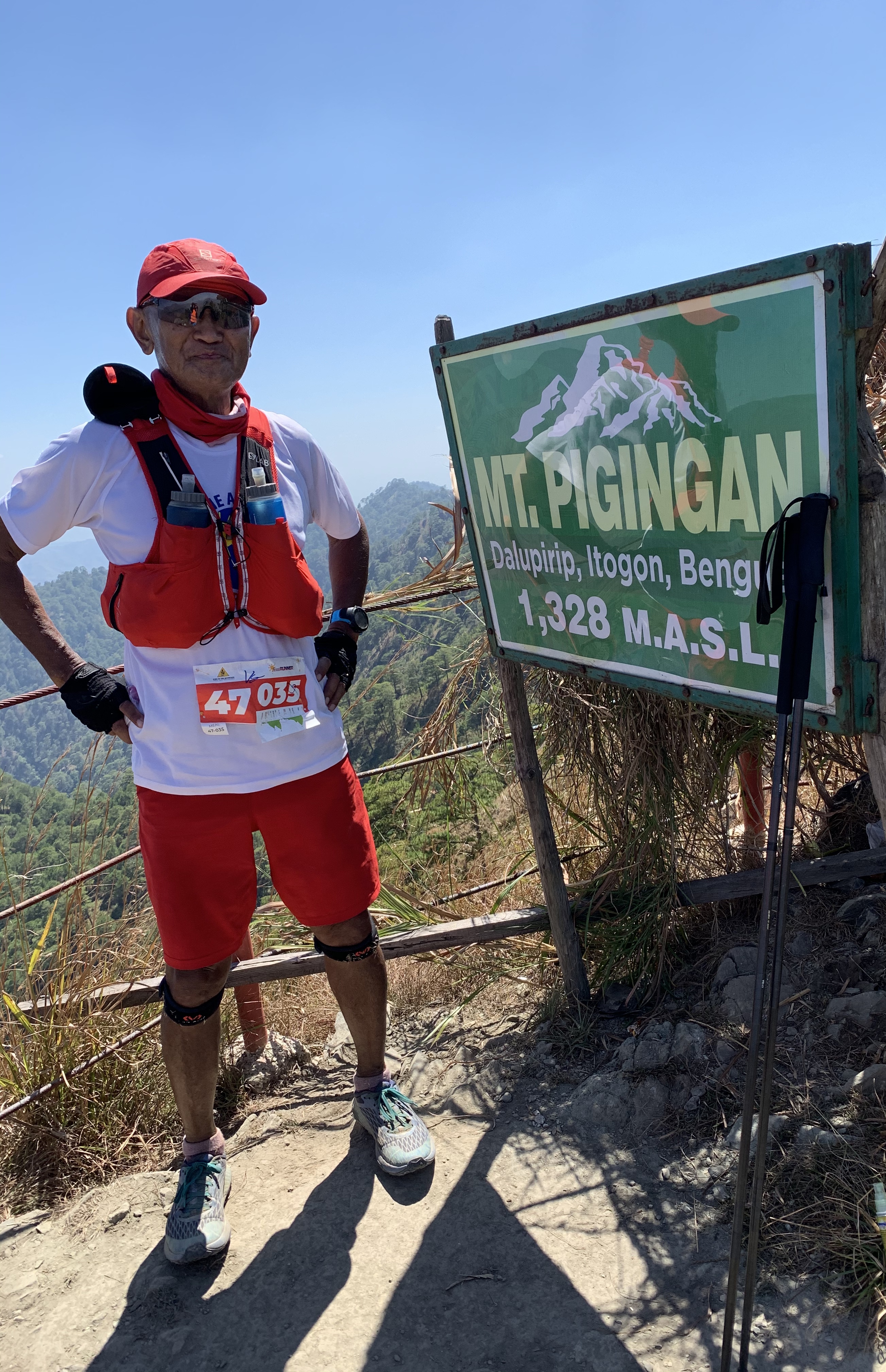
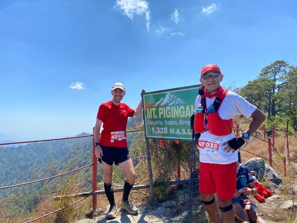
Finally, I reached the Tivang Water Station (Km 28). I stopped, refilled my bottles with water, and ordered some Coke, Eggs,and Boiled Banana from the local peddlers thereat. I guess, I took a lot of time for the first time to rest and eat at this point. I took some time to rest and have stayed here for almost 25 minutes. With enough water, I left Tivang and slowly passed some runners ahead of me. It was a relentless 3-kilometer distance of climbing from Tivang to the Peak of Mt Pigingan (Km 31). My trekking poles were helpful at this point. The Peak of Mt Pigingan looks like an “arrowhead” that it took me 10 minutes to reach it from the its base which has only a distance of 10-15 meters.
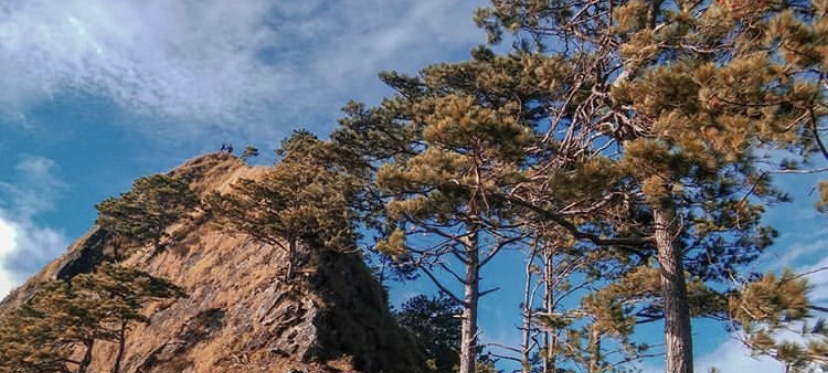
To give justice for all the hardship, pain and heat to reach the Peak of Mt Pigingan, I asked the Marshal to take a picture of me with the marker as the background. I had a chance also to have a picture of Bob/Robert, a British trail runner, who arrived ahead of me in the said peak. I did not take a few more minutes to stay in the place and slowly made my way down to the base of the peak. As I moved going down from the mountain, I met a lot of runners who were asking me how far was the peak. I have to answer them through some estimates which was nearer in distance than the real thing. I really did not want them to be frustrated if I told them the truth.
Finally, I reached Tivang Water Station (Km 34) and I ordered the same food that I have eaten before I went out towards the peak of Mt Pigingan. I stayed here for another almost 25 minutes and brought with two pieces of Ice Candy. I thought we were going to follow the route for the 32K runners from Tivang but only to find out that we have another mountain peak to reach which is Bantic (Km 37). It is another relentless uphill climb for 3 kilometers under the heat of the sun. The Ice Candies I had with me were very comforting but with the steepness of the climb, it gave more toll to my tired knees and legs. But through patience and lots of 10-seconds rests along the exposed route, I was able to reach the peak and hoped to have a faster downhill trek towards the next Aid Station.
I guess, I was wrong! The winding single track downhill route was so tricky and steep that I could not increase my speed at this point. Some portions were covered with dried leaves and some have loose tiny rocks which would cause my trail shoes to slide even if they have aggressive studs on their soles. The descent is another 3-kilometer distance which most of the sections are very steep. At this point, I was thinking that I could no longer reach the Tabu Bridge Aid Station within the cut-off time of 12 hours. As I reached the base of the mountain at the Langag Water Station (Km 40), I refilled my hydration bottles and immediately left the said AS. I finally crossed the bridge and reached Tabu Aid Station (Km 42) with barely 2 minutes before the cut-off time.
Shit Happens
At the Tabu Aid Station, I entertained the idea of eating a glass of Halo-Halo (concoction of sweet fruits, milk, sugar, and crushed ice) but after eating it, I started to have an “acid reflux” (aka throwing up the fluids and foods I have ingested in the said Aid Station). The marshals and some of the runners offered help by giving me some medications and ginger tea to ease my stomach problem. I was asked by the Marshal if I would declare myself as DNF at the said AS since I have only 35 minutes to spare before the cut-off time of 13 hours but I replied that I would try my luck to just run and hike up to the Finish Line.
Five kilometers in 35 minutes? In the end, I was able to cover a distance of 4 kilometers only when my watch registered a time of 13 hours. After this, I just simply hiked until I reached the Finish Line. I found out later at the Finish Line from the RD that there were more than 20 runners behind me who were declared as DNF at the Tabu Aid Station.
Post Race Assessment
I am still happy that I was able to finish the race even if my time was longer than the prescribed cut-off time of 13 hours. My training using my “weighted backpack” gave me confidence to hike relentlessly on steep uphill climbs. The heat experience I got from this race was just part of my training for my future races but I need more of these type of races for me to adjust to hotter environment. I need to fix my problem on the occurrence of “acid reflux” during my ultra races and better learn how my body would prevent this from happening. I stayed and spent so much time at the Tivang Aid Stations (going to the peak and back) and at the Tabu Aid Station on my way to the Finish Line. Lastly, in KOTM races, expect the published distance to have an additional bonus distance of either 1-2 kilometers.

Overall, I am happy with my performance in this race.

You must be logged in to post a comment.