Sometime in August 2015, I featured Conrado “Jun” Bermudez, Jr in this blog as the First Filipino Runner/Ultrarunner to have finished a 200-Mile Mountain Trail Single-Stage Endurance Race at the Bigfoot 200-Mile Endurance Race in Washington State, USA. It was in the post in this blog where I wrote about his background and running accomplishments since he became a passionate runner. For this year, 2018, he finished the Ultimate Award in Ultrarunning in the United States which is the “Grand Slam of Ultrarunning” Eagle Award and I was able to send him an e-mail to congratulate him on this inspiring feat which is considered as a “dream” to be accomplished among the best ultarrunners in the world. I also sent him some questions to answer of which I am now publishing his answers in this blog.
BR: Congratulations on your 2018 US Grand Slam of Ultrarunning finish! That’s a huge accomplishment and biggest pride for being the First Filipino to receive the Eagle Award in Ultrarunning. You are now Finisher #354 out of the 363 Finishers of the GSU since this award was created in 1986.
As usual, hoping that you will have the time, I am sending you some questions for you to answer which I will publish in my blog. There is no deadline though as I know you are still resting and recovering.
Jun:Thank you for this opportunity to be included on your blog, sir. Thank you also for mentoring me when I started my ultrarunning way back in 2013. As a Filipino citizen, it is a great pleasure and honor to represent our country in this sporting event. My heartfelt gratitude to all the support!
As a 45 year-old runner, joining the Grand Slam was a no-brainer. There was no shadow of doubt not to join. It was a once-in-a-lifetime opportunity and this chance may not be available to me in the future. If it is going to happen by that time, I may not be physically that capable anymore for the challenge due to old age.
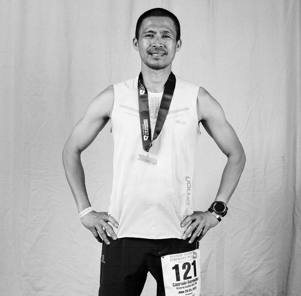
Jun Bermudez Western States 100 Picture
BR: What is your feeling now that you have finished the US Grand Slam of Ultraruning with an impressive time of 106:52:09 hours and the First Filipino to have received the prestigious Eagle Award in Ultrarunning?
Jun: I am deeply delighted and humbled to be part of this 32nd year of the Grand Slam of Ultrarunning, a special historical event in ultrarunning world. It still feels surreal that I was able to finish them and trace the footprints of the first finisher, Thomas Green, in 1986 and the grandfathers of the five 100 milers. These races are the oldest 100 milers in the US or probably in the world with the Old Dominion 100-Mille Cross Country Run for 40 years, Western States 100-Mile Endurance Run for 41 years (the oldest in the world), Vermont 100-Mile Endurance Run for 30 years, Leadville Trail 100 Run for 35 years, and the Wasatch Front 100-Mile Endurance Run for 38 years. Just to be entered in the Grand Slam of Ultrarunning events, itself, is a privilege. It takes a lot of luck in the lotteries (Western States 100, Leadville 100, Wasatch 100) to get entered in the same year. All of the races, except Wasatch 100, do not give provisional entry anymore. For non-lottery events, the Vermont 100 is a first-come-first-served basis and the registration sold out in less than 15 minutes when it opened, and the Old Dominion 100 got filled up weeks before the event date which normally did not happen in previous years. My success was not possible without the support of my friends and, of course, the encouragement, the love and understanding of my wife and my daughter.
BR: You are one of the few Eagle awardees who finished and completed the FIVE Races in a span of three months, what was your recovery in between these races?
Jun: The Grand Slam is arduous to complete. The three to four weeks of minimal time for recovery between races and the cumulative fatigue put so much toll on our body.
I ran two road marathons in April (Boston and New Jersey) prior to the Old Dominion 100 (02 June). I started my taper three weeks before the race day so my body could fully recover. In between races, my first week of recovery consisted of moderate stretching and no running, which were slow hiking and light spinning workout. For the first two days after the race, I was doing ice therapy on my feet to remove the inflammation. And mostly during the period, I was doing a dynamic compression of my legs to flush out waste and hasten muscular recovery. Also, I am sleeping with my legs elevated almost every night even when I am not on training because I spend so much time on my feet at work with the load (tactical gear) on my body. I was taking Essential Amino Acids (EAA’s) complex to include Branched Chain Amino Acids (BCAA’s) to stop muscle tissue breakdown and reduce muscle soreness. It would take three to four days after the race for my legs to feel fresh and pain-free again. I was also consistent with my bodyweight strength workouts all throughout the Grand Slam.
In the second week and onwards, my recovery usually started with 30 minutes of easy running then alternated the next days with spinning and short tempo or intervals (controlled pace) on the treadmill.
A week before race day, I spent most of the days resting and sleeping. My routine was
taking two nights of having eight to ten hours of sleep two to three nights before the event so I would regain my energy and not be sleepy during the race. Although my recovery plan was not perfectly executed, I was still able to prevent injury and was able bounce back to be prepared for another adventure, and nailed them one by one to enjoy the experience.
Below is the illustration of events with their respective dates:
Old Dominion (02 June, Saturday) > 3 weeks >
Western States (23 June, Saturday) > 4 weeks >
Vermont (21 July, Saturday) > 4 weeks >
Leadville (18 August, Saturday) > 3 weeks
Wasatch (07 September, Friday)
BR: It seems that you did not have any “issues or concerns/injury” in every race, how did you manage to fight the “demons” (heat, exhaustion, muscle cramps, if any, GI issues, altitude, and “bonking”) during these races? What was the “hardest race” in this series of race?
Jun: My body held up very well. I do not have injuries since I started running ultras in 2013 except for my sprained ankle that I twisted during the HURT 100-Mile training in early December last year. I think my training on incline trainer/treadmill has preserved my legs to be stressed and injury-free. With my work schedule, at least 85% of my training was conducted indoor.
100 miles is a long journey but a manageable distance. For that long, I experienced nausea, vomiting, GI issue, and cramping during races. But I embraced them as my “normal”. I approached these races in a simple way, to control them by avoiding mistakes. As my spiritual endeavor, I ran the five races solo (no pacer, no crew) and dug myself deeper and fighting the adversities alone. One key to success is I put my heart and soul in this endeavor.
In my training, I focused on the elements that could eventually hit me during races. Since these are summer series, heat is the biggest factor. The US west coast has a dry heat with extremely high temperatures while the east coast has high humidity that brings to higher heat index. Twice or Thrice a week I was doing heat training on my incline trainer from one hour to a maximum of five hours wearing a double layer of thermal gear and raising our room temperature to make it hotter. To complement my heat training, I was wearing my armored vest at work for the whole day even during the hottest days. During the race, I was wearing a hat, bandana, and arm sleeves where I placed ice cubes in them. All of these help to neutralize my body temperature. So, for heat, I was really prepared and it did not bother me during the races.
Another element that is quite difficult to prepare is altitude. It is the most dominant factor that resulted to a huge number of DNF (Did Not Finish). Shown are the high altitude races of the Grand Slam with their corresponding highest elevation: Western States 100 (8,750 ft/2,667 masl), Leadville 100 (12,600 ft/3,840 masl), and Wasatch 100 (10,467 ft/3,190 masl). There are also significant sections of the courses that are above tree line. This is my weak point as a sea level flatlander. I incorporated speed work on my training since running on altitude is ran at slower pace. Although it does not really contribute on acclimation, it is still beneficial to run the race faster in order to have enough buffer from the cutoff and finish it with less pressure.
Among the Grand Slam events, the Old Dominion 100 and Vermont 100 have the fastest courses with 66.27% and 79% finish rate, respectively. Old Dominion has a cutoff of 28 hours. They are a runner’s race since the climbs are not long and steep. But the Old Dominion could be surprising. The Sherman Gap section is a steep technical climb. These two courses are on low elevation but with high humidity. In Western States 100, I suffered a lot of cramping in most parts of my legs starting at the early miles until halfway. The second half was even worse when I had a stomach issue. The course is point to point mountainous terrain but it got easier in the second half with the course going more downhill than uphill. I felt that among these races, my body was beaten up the most here. Despite the heat, it has 81% of finish rate. In Leadville 100, cramping was not that significant but I was nauseous the whole time. I did not have solid food intake all throughout the race. Every solid I took just went out. I went to Colorado 13 days before the race. But even with acclimation, breathing during a long climb in Hope Pass was a struggle. The air is just so thin that I could not push hard. The cutoff of 30 hours also made the race harder. The high altitude and fast cutoff contributed to a low finish rate of 57.9%.
The most difficult event for me is the Wasatch 100. It has a 62% finish rate. After four races, my body was not primed to run anymore, especially that my legs felt sluggish. The nausea hit me after a quarter of the race and I could not take solid food again. The course has more climbing and it is on high elevation. It was also the second hottest temperature in the history of the race. This year a significant number of bees were scattered in different sections of the course, which was difficult to avoid. Some got stung 14 times. Fortunately, I was only hit twice. Although this is the most technical course of the Grand Slam, this also has the most beautiful scenery. During this race as I was to retrospect the past four races, and the long journey of trials and tribulations, I was feeling highly and spiritually rejuvenated since it is already the finale of my Grand Slam journey.
I have some friends and compatriots who shared the trails with me and it lifted my spirit and energy. Thanks to Casey Fisher (Old Dominion, Western States, Leadville), Jovencio Luspian (Western States), Tim Aquino (Leadville), Kian Vicera(Leadville), Philip Pagdanganan (Leadville and Wasatch), and Ryan Espulgar (Wasatch) for friendship. The memories we have will be forever etched in my heart.
BR: What would you recommend or advise to Filipino Ultrarunners who would plan to complete or join this series of Ultrarunning Races?
Jun: The new system of the Grand Slam (started two years ago), which includes four of the five events with Wasatch 100 as a mandatory race, has given more opportunities for runners to join without undergoing through the virtually impossible selection process of the Western States 100.
The Grand Slam events per se involves time and money. As a starter, if a runner can afford the financial and logistical burden, and manage the time schedule, non-running-wise, he is ready to tackle the series. We just live once anyway. Taking the Grand Slam challenge is a priceless opportunity and a big milestone.
In the Grand Slam, a runner can choose what series he wants to attempt. A total of 18 finished this year from 28 starters. These are the variations with the corresponding number of finishers:
1) original version: Old Dominion, Western States, Leadville, Wasatch Front. None (except the two who did five races)
2) pre 2017 version: Western States, Vermont, Leadville, Wasatch Front. Seven
3) Old Dominion, Western States, Vermont, Wasatch Front. Six
4) Old Dominion, Vermont, Leadville, Wasatch Front. Three
5) Old Dominion, Western States, Vermont, Leadville, Wasatch Front. Two
In my personal point of view, the core of the Grand Slam are the Western States and the Leadville, aside from Wasatch Front which is mandatory. Missing either one of them could mean not a “complete” satisfaction for me. Leadville is known for being a grandslam-killer. And these two races are icons in the annals of the 100-mile races worldwide, especially the Grand Slam series.
Another step is to find a Western States 100 qualifying race that has more climbing and elevation in order to get used to the mountainous course. Applying for lottery every year gets a runner more chance to be picked.
In Leadville 100, there’s a 50% chance to be selected in the lottery. In the essay part of the application/registration, a runner has to indicate his willingness to be entered into the Grand Slam and make a convincing story of his running journey to get a better chance to be selected. Although it is a lottery, I still believe that the race organizer gives considerations to this special request.
Wasatch Front 100 is the mandatory and final race of the Grand Slam. It is also a lottery and the chance of getting in is high. If in case a GS entrant will not get picked in the lottery, the race organizer gives a provisional entry, meaning the entrant has a chance to run Wasatch if he is successful on his third race.
Another aspect to consider is the physical and mental readiness of the runner. Experience is a huge factor. So, doing back to back races that have difficult terrain is a good test. This is also to develop the physical stamina as well as to harden the mental fortitude of the runner. Most of the time, it is the indomitable spirit that brings the runner to the finish line.
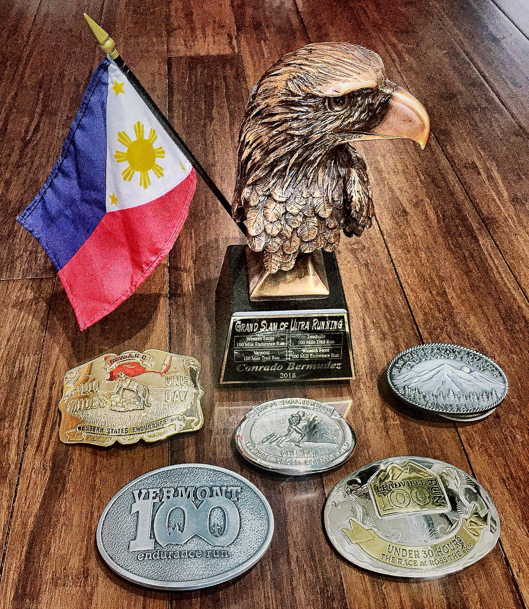
US Grand Slam Of Ultrarunning Eagle Award & Finisher’s Buckles
BR: Having closely followed your Ultrarunning feats and accomplishments, you have only 2 DNFs, Barkley Marathons and UTMB. You redeem yourself in the 2017 UTMB and you finished in one of the coldest UTMB race. Do you have plans of going back to Barkley? What are your future races?
Jun: The Barkley is not in my thoughts right now. Being out there knowing the difficulty of the course, that five loops is an impossible feat. It is arguably the toughest race I ever experienced. I gave my all and had managed to finish one loop. I do not have a definite race for next year except for the Boston Marathon. I threw my name for lotteries in Hardrock 100 (5th year application) and Western States 100 (1st year application after getting in this year). There are some interesting races that I want to do in the future, maybe another mountain 200 miler and road ultramarathon. Some of the races that I did are also worth coming back. I love the electrifying spirit of UTMB, Leadville, and Western States, and also the old traditional and small community feel of the Old Dominion.
BR: Lastly, Did you get the services of a Professional Coach in preparation for this year’s events and what shoes did you use in your Grand Slam Races?
Jun: I did not get the services of a Professional Coach and I did my training on my own. I used the Hoka One One Mafate Speed 2 for Old Dominion and Western States and Hoka One One Mafate EVO for Vermont, Leadville and Wasatch Front.
Thank you, Jun for answering my questions. Your answers are considered as “Gold Mine” for those ultra runners, Filipinos or Non-Filipinos, dreaming to be a Finisher of the US Grand Slam of Ultrarunning. Keep inspiring us and good luck on your future runs/races.
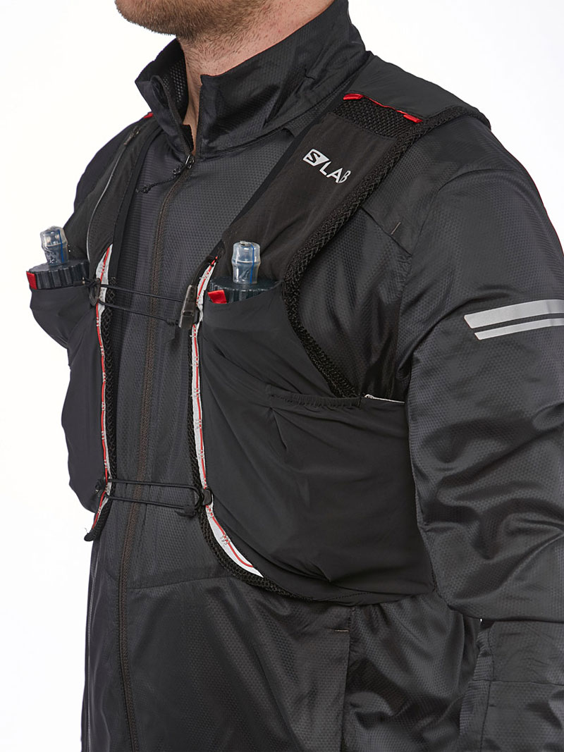
Clothing & Gear: I think I used the best clothing gear, from trail shoes to my headlamp lighting system. My “layering” of my upper garment was perfect with a sleeveless Uniqlo shirt inside my Red PAU short-sleeved shirt with my Patagonia “Houdini” Windbreaker Light Jacket. I feel warm with my MIUT Buff/neck Gaiters; Compressport Headband and Salomon Running Cap. I had Giro Cycling Gloves with my LEKI Carbon Trekking Poles. My Salomon Speedcross 4 was perfect for the trail in Lavaredo which I used for two months in my training leading to the event. I was using a Salomon EXO Twinskin Short (Red) which was light, comfortable, and provided me with warm feeling during the night run.
Salomon 5L Sense Ultra Hydration Vest & Pulse Belt: My Salomon Vest carried all the Mandatory Gear and Nutrition Needs for the whole course/event as I opted not to have any Drop Bag at Km 66/Cimabanche Aid Station. My Salomon Pulse Belt was perfect for my Trekking Poles; additional nutrition (Skyflakes) and Cellphone.
Training: My “mountain and hill repeats” were very effective for the uphills and downhill runs for short duration/distance along the course.
Nutrition & Hydration: I only have 5 pieces of Power Gels for emergency situation; 6 pieces of KIND Power Bar; 4 packs of SkyFlakes Crackers (Condensada); NUUN tablets: and two pieces of empty Ziplock.
Pacing & Average Speed During The Race: I have a lot of lessons learned from my early DNF at MIUT in Madeira, Portugal. I needed to be very light during the race and trained for heavy loads (3 Liters of Water + Food) in my daily long runs in my Playground. I was satisfied with my average speed/pacing during my run at the TNF Lavaredo until I was slowed down with dizziness and pain on my knees.
Salomon S-Lab Sense Ultra 5 Liters
What Did I Do To Make It Right?
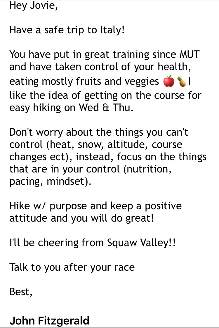
My frustration in MIUT last April gave me a lot of lesson learned and I was able to adjust things during my training. My early arrival in Cortina gave me the time to adjust with the weather and the altitude. However, I should have visited Tri Cime and other higher elevations of the course by Bus but with my lack of knowledge of the area, I was limited in trying to find the first and last few kilometers of the course. My CTS Coach John Fitzgerald sent me his last guidance with the gist/bottomline of focusing on the things that I could control during the race (nutrition, pacing, and mindset) with hiking with purpose and positive attitude. I learned a lot of variations on how to use the trekking poles during my training leading to this race. I really wanted to hike the uphills more efficiently with the trekking poles. I had more “push-ups” repetitions during my training days in order to make my shoulders stronger than what I had during MIUT.
Bringing lesser gels, bars, drink mix, and lighter mandatory gear (Salomon Bonatti Waterproof Jacket & Pants and Columbia Long-Sleeved Shirt) made my weight lighter during the run. I also carried lesser volume of water from the start to lighten my load but also carried an extra collapsible Salomon Foldable Bottle just in case I needed more water during the hotter part of the day.
After hiking the uphills, I would run at an easy pace on flatter and downhill portions of the course which gave me enough time to reach the First Cut-Off Time Checkpoint and put in more buffer time at the Check Point in Rifugio Di Auronzo.
Bring at least two empty Ziplocks in your pocket (easily accessible) for obvious reason.
Last Message Of My CTS Coach
What was NOT quite right during the race?
I opted to run the downhills on the early part of the course without using my trekking poles, most specially, on the seemingly flatter sections but they are actually gradual descents. I was thinking that I would be faster in running the downhills by not using the trekking poles but I was wrong. If only I have used my trekking poles on all the descents, I could have saved my quads and my knees from having pain even if I was slower by a few minutes. My old knees and legs need some cushioning when running the descents to preserve them for the last half of the course which has more descents.
I should have started to ingest my solid food on the start of the uphill climb from Lake Misurina to Rifugio Di Auronzo while on the move and not at the middle of the climb with a 3-5 minutes short stop and rest.
I should have NOT stayed so long at the Aid Station in Rifugio Di Auronzo and spent a lot of time sitting and talking with the Indonesian guy. I should have limited my stay there by simply eating the soup pasta, drinking my Coca Cola, and refilling my bottles while I was standing. I could have shaved at least 10-12 minutes of my stay here.
I really could not understand why I did not take the risk of taking some Aleve tablets to relieve the pain on my knees after the first switchback from Tri Cime/Peak of Lavaredo. I usually take these pain relievers on the middle of my race just to anticipate the pain on my knees which was very effective in solving the situation I am in in my past finishes.
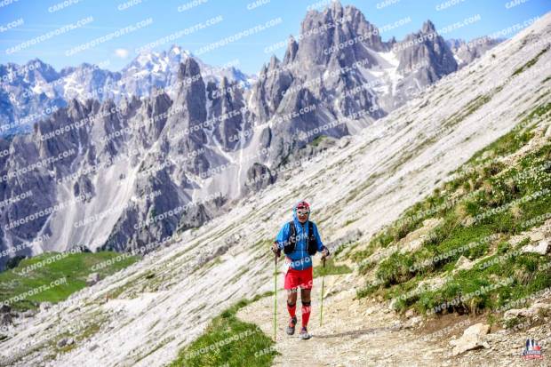
At The Peak Of Lavaredo
What is the best-case scenario?
1. With a buffer time of 40+ minutes from Rifugio Di Auronzo, I should have maintained it up to the next Cut-Off Time Checkpoint in Cimabanche and gambled any remaining buffer time in every Checkpoint up to the last Cut-Off Time Checkpoint before the Finish Line.
2. I could have used my trekking poles more on the downhill/descents to save my knees/legs and be able to hike relentlessly with purpose up to the Finish Line. The time that made me faster to run or hike on the flatter and downhill sections without the trekking poles was nothing if I could have saved my legs and knees and be able to pass the Cut-Off Time Checkpoints.
3. From the start, one bottle of water/electrolyte mix (500 ml) is enough up to Km 33 to make my load lighter from midnight up to early morning due to the colder air/weather. One bottle filled with liquid in one bottle and another 1/2 bottle of liquid, totaling to 750 ml is needed from Km 33 up to the Aid Station in Rifugio Di Auronzo (Km 50). Carrying just the right amount of water on my vest could significantly reduce the weight I was carrying. Which translates to lighter load to my knees and legs.
What steps can you take to improve?
1. More strengthening exercises to my leg muscles. More push-ups and core exercises for my upper body.
2. More time to train for very LONG downhill running or hiking with the use of trekking poles. Downhill running/hiking distance should be at least 10 up to 20 kilometers straight down, whether they are steep and technical or not. (Note: Never stop using the trekking poles once they are deployed; in uphills, flats, and the downhills.)
3. More Mountain Downhill Repeats! Simply, the reverse of Hill/Mountain Repeats where one has to run or hike the downhill faster than going up to the mountain. This time, using my trekking poles!
4. Bring a lot of BUFF. One for the Ear Cover; one for the Mouth & Nose for the absorption of fluids due to “running nose”; and one for the neck. In addition, I can bring an extra BUFF to be looped on my wrist just in case I need a cloth to absorb some cold water from the streams to douse my head and neck during hotter part of the day.
5. If I have the time, I could have visited/recon by Bus or Car the highest peak or highest location along the course in order to acclimatize or take a brief hike.
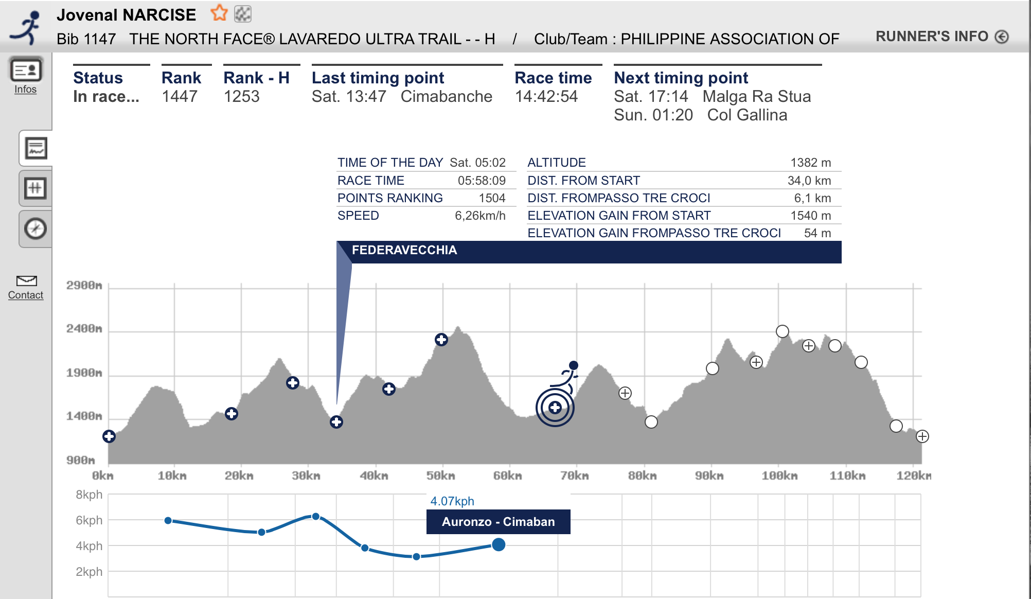
@ Federavecchia (Km 33.5)/First Cut-Off Time Checkpoint
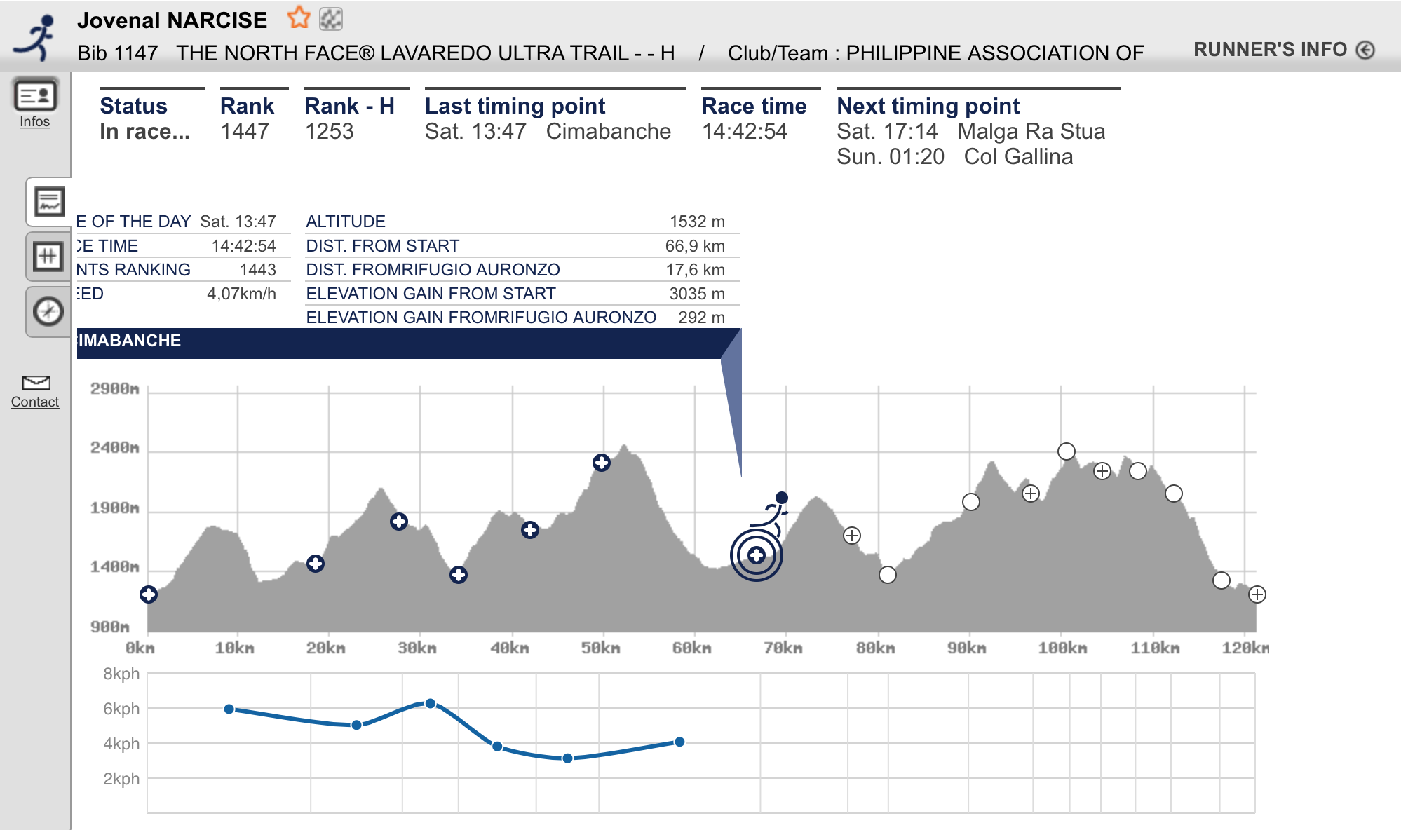
Reaching this First Cut-Off Time Checkpoint at Federavecchia within 6:30 hours was my primary concern and target just to redeem myself from my frustration on my previous performance at the MIUT in Madeira, Portugal on the last week of April this year. I was happy and excited that I was able to build-up a buffer time of 32 minutes. With my age of 66 years old, I could be the happiest person among the runners that reached the said Aid Station.
1st Cut-Off Time Checkpoint @ Km 33.5 in 6.5 Hours/Average Speed: 6.26 KPH
I immediately brought out my almost empty Salomon Bottle, drank the remaining liquid and had it filled up with water, dropped one tablet of NUUN, and placed it back on the vest. Brought out an empty Ziplock bag from my vest and immediately filled it with apple bite cuts and dried apricot and immediately left the Aid Station. It took me less than 2 minutes to do all these things. But as soon as I left the Aid Station, I was facing a straight steep uphill climb.
I started to eat what I took from the Aid Station while I was hiking up the uphill climb which is an asphalted road that can accommodate three runners abreast with each other. The uphill climb consisted of more switchbacks and it lasted for about 2.5 kilometers. It took me two times to eat the fruit bites from the ziplock and they provided me the much needed energy to reach the peak of the third climb of the course and was able to reach Plan Maccetto which is almost Km 39 from the Start. From this point, I started to run on a single track trail which was a soft ground with with lots of small grass around. Even if this place is still considered in a higher elevation, my “running nose” and numbing hands had stopped and the temperature was becoming warmer to my body. After about 3 kilometers of running downhill, I finally reached the edge of a body of water which is called the Lake Misurina!
Tip: You can master the art of filling the Aid Station’s food with an empty Ziplock Bag. It will save you some time, instead of standing while eating your food at the Aid Station. Keep moving while you are eating and hydrating.
Lake Misurina
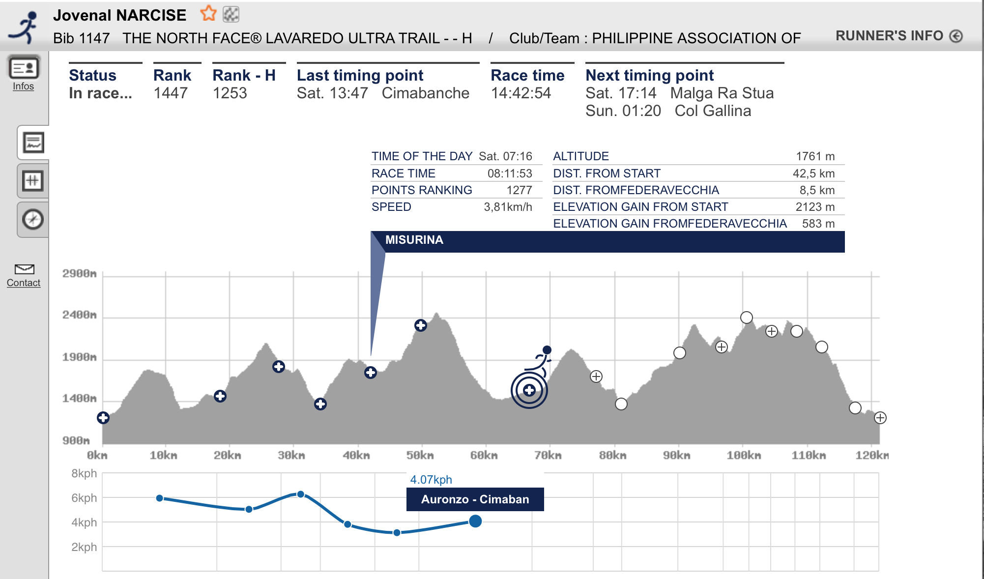
Lake Misurina is a beautiful lake with very clear water. I was tempted to take a “selfie” and picture of the lake & the surrounding mountains but I promised myself not to bring out my cellphone during the course of my run. The three of us Pinoy runners had talked about not having pictures along the course since it will delay our run/hike from Aid Station/Checkpoint to the next one. Knowing that there are Professional Photographers along the course in different strategic locations, there was no need for “selfies” or picture-taking on the scenery. It was another 1.2 to 2 kilometers run on a wide dirt road surrounding the Lake before I reached a Lady Marshal who was holding a Time Scanner. She tagged me and I asked her how far was the next Cut-Off Time Checkpoint and she replied “10 kilometers”. But looking on the map/elevation profile on my Race Bib, it indicates a distance of only 7 kilometers! I wonder which is one telling the truth, the Lady Marshal or the Map printed on the Race Bib?
@Lake Misurina/Average Speed: 3.81 KPH
After I exited from the periphery of Lake Misurina, I was now following an asphalted road that was going up to the mountain but the runners were directed to run along the dirt path/trail beside the paved road as shown and depicted by the trail markings. It was doing an alternate hike on the paved road and then going back to the dirt track beside the road and back again to the paved road at this point using my trekking poles. I was able to pass by an Asian guy and I started to have a conversation with him. He told me that he is from Hongkong and he was busy looking at his cellphone. Thinking that he was checking on our route through his cellphone, I asked him about the actual distance (while hiking uphill) to the next Aid Station and he answered “I don’t know!” That’s it! That stopped my conversation with him and I just tread on with my fast hiking.
Tip: The main reason why a cellphone is an important mandatory gear is that for communication purposes to the Race Organizer in cases of emergency and not for photography!
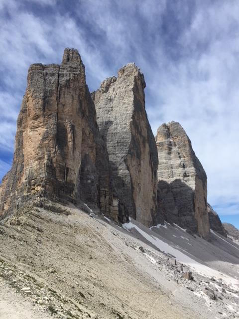
Rifuego Di Auronzo
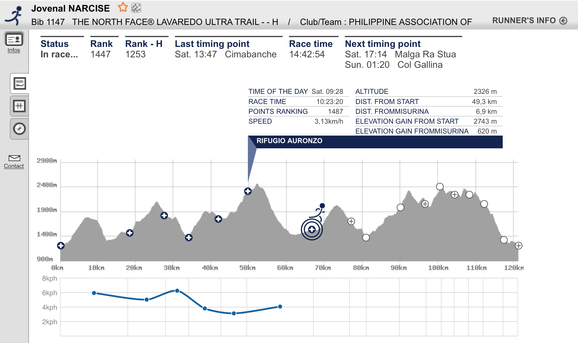
From the paved road, I veered right from the highway and followed a single-track trail that seemed to be going flat and downhill but it was a short one. Looking up ahead of me, I could see from the distance, the iconic Rifuego Di Auronzo where the famous 3-rock mountain formation is located! The Tri Cime mountain formation is the LOGO of the TNF Lavaredo! By looking at the next Aid Station at the Tri Cime, I had a mixed feeling of delight and sadness as I need a lot of strength to reach the highest point of the course. The single track trail was a relentless uphill climb which is about 2-3 kilometers of steep winding uphill assault. As I was about to crest the last “false” peak, I stopped and ate two packs of Skyflakes Condensada and followed it with a Clif Power Gel. I was able to regain my strength after that and I was able to reach the Aid Station and Cut-Off Time Checkpoint at Rifugio Di Auronzo in 10:23 hours! I was able to accumulate a buffer time of almost one hour at this point.
It was an awesome sight to see the Tri Cime in Lavaredo, Dolomites and I became in love with the place! But before I could absorb what I was seeing and feeling at that moment in a place so beautiful to be at, I need to refill my bottles and ate some pasta soup with powdered cheese at the Aid Station. I was seated beside an Indonesian runner and we had a short conversation. The Indonesian happened to be in the same hotel where I was staying and he arrived later than me in Cortina. He is 54 years old and he looks like he is from their uniformed services. I think I was able to spend at least 15-20 minutes in this Aid Station. Finally, The Indonesian and I left the Aid Station at the same time. However, he was stronger and faster than me in hiking with his trekking poles.
Tip: Never, never, never stay at the Aid Station for more than 5 minutes if you need to eat and rest thereat.Never have the temptation to sit!
It was a flat downhill wide dirt road from the Aid Station which is about one and half kilometer and we had at least 3 kilometers more of uphill climb to reach the peak of the Lavaredo Mountain which is the highest point of the course. I could still keep in step with the Indonesian guy on the first 1.5 kilometers but when we turned left for the steep uphill climb, he made a considerable distance from me but I could still see him from afar. I think I was able to reach the highest point in almost one hour from the Aid Station. I think it was at this point where I was able to meet the Official Photographers of the Event. It was also at this point that at least 3 local runners, coming from behind me, tapped my shoulders and cheered me & congratulated me for reaching the said place!
Peak of Lavaredo Mountain
Finally, I reached the peak of the Lavaredo Mountain where I could see the North side face of the Tri Cime! As I hiked the first few meters going downhill, I was excited and happy to have reached at this point. Since my Garmin GPS Watch had been connected with my USB Charger, I could not see what was my actual distance at this point but on the Map/Elevation Profile as reference, it could be at Km 51.
@Rifugio Di Auronzo/Average Speed: 3.13 KPH
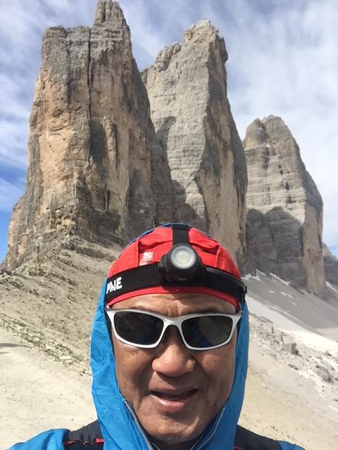
After hiking downhill for about 250 meters, I started to feel dizzy. The feeling was like I was drunk with Irish Whiskey and became sleepy! It was almost 10:00 AM (actual day time) and the weather was mild (but I was still wearing my Patagonia Windbreaker with the hood on my head). I panicked and I had to rest and lean on right side of the trail/dirt road. The left edge of the road is deep ravine. While resting and taking in some deep breath, I was tempted to bring out my cellphone and took the picture of the Tri Cime. After taking the picture and drinking some sip of my electrolytes, I resumed my hiking! However, after another 100 meters, I felt some dizziness again! Instead of stopping, I reduced my pace and went nearer to the right side of the trail just to anticipate that if I fell to the ground or pass out due to dizziness, I will not fall to the ravine. I became nervous as I hiked with the thought that I might pass out at this place and be air-lifted with a helicopter or just pass out to die while I am on this place of the earth. All of these things were in my mind, trying to figure out what could be the best to do in this kind of situation. I guess, a simple prayer did the trick and more deep breathing to remove the feeling of dizziness while I was hiking slowly towards the first switchback of the downhill course!
Tri Cime Of The Dolomites
Tip: If you think something is wrong with your body, STOP, take a rest, relax, take a deep breath, and enjoy the scenery. Re-assess yourself, PRAY and resume slowly.
The first switchback along this downhill course from the Tri Cime/Peak of Lavaredo is being guarded by Park Ranger or Polize (?) who were in Red Uniform. From this switchback, it was a steep, rocky and very technical single-track trail which is about 2-3 kilometers of more switchbacks. As I hiked and jogged this portion, I started to feel some pain on my left knee and my quads were already feeling to had been trashed. As I crossed a dry river bed on the bottom part of this trail, I could hardly lift my legs and my left knee pain became more painful. I tried to hike on the flatter section with my trekking poles to relieve the pain on my knees and rest my trashed quads.
My ONLY “Selfie” During The Event
I could feel already the warm air on the lower elevation of the course and I started to have some sweat/perspiration and tried to lessen my thoughts about my left knee pain. I did not remove my Patagonia Windbreaker and instead, just removed the hood from my head and I could still feel the cold breeze passing on my head.
Landro To Cimabanche
Finally, I was on the last 3 kilometers before the Aid Station/Cut-Off Time Checkpoint at Cimabanche (Km 66.9) and I started to do whatever “speed drills” and “strides” I did in my training in order to speed up my pace. The wide dirt road seemed to be flat but in reality, it is a gradual uphill climb up to the Checkpoint. I tried to do all my best to reach the Aid Station within the cut-off time in 12:30 hours but I was thinking already that my race was done once I reach at this point. My aching left knee could no longer withstand the next 53 kilometers of more challenging climbs and steep descents, thus, I could no longer accumulate some buffer time in every Checkpoint. I was envious of those local Italians who were cycling on this road with their nice jerseys and expensive Mountain Bikes, as they would pass or meet me along this road. I just entertained myself on looking on these young men and ladies biking on the said road.
The “sweepers” were able to reach and catch me on the last 50 meters before the Aid Station. One of the sweepers started a conversation with me after he saw on my Race Bib that I came from the Philippines. He told me that his wife is a Filipino and she is from Digos City, Davao Del Sur and they have some children (I forgot how many) and he showed me the pictures of his wife and children in his cellphone while we were jogging. He even asked with a “selfie” with me! Wow! These Italians are like Filipinos and they like/love Filipinos!
Cimabanche: The End Of The Line/Average Speed: 4.07 KPH
I missed the cut-off time by almost 13 minutes!
Tip: Listen to your body…always! Determine your limits and gracefully surrender in defeat. There will always be next time to redeem yourself. You can not fight against nature if you are already weak and injured. You will never win!
While we were in the bus going back to the Ice Olympic Stadium in Cortina, I counted the number of runners who DNFd in the Aid Station and I was able to count to 12 and I was the oldest, I think. I just smiled and one the ladies (from Croatia or Poland?) in the bus (who smiled and winked at me in one of the previous Aid Stations, I guess, in Rifugio Di Auronzo) was also there and she smiled at me, too before I was able to sleep during the ride!
I have a lot of DNFs in my previous attempts to finish a 100-mile mountain trail run here and abroad and many are wondering why I would just simply finish one of my ROAD 100-mile ultras in my races and earn those buckles that I have designed. One of the important reasons why I insist on finishing a 100-mile trail run is because I have already transformed myself as a mountain trail runner after the conduct of the 1st Taklang Damulag 100-Mile Endurance Run. Since then, I limited my exposure to road racing as well as training on paved roads.
Maybe, my old age is fast catching up on my body that I need to spend more time in the mountains. However, more effort is exerted on my muscular and respiratory systems while I am in the mountains but after every run or hike I feel energized and more relaxed. It could be due to the following: the nice sights & scenery of the place where I came from, the clean and unpolluted air that I inhaled, or the variety of the ground where my feet would land that makes me more agile and fast in thinking. And the list gets longer with so many more reasons…
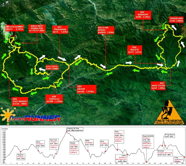
Fast Forward…The Hardcore 100-Mile Mountain Trail Run is very close to my heart as I was a part of the RD’s team to recon and measure the route for the first time within the duration of three consecutive days. We started in Kayapa, reached the peak of Mt Pulag, spent two nights in Balite, and then exited on the trailhead in Ambaguio, Nueva Viscaya and later linked up with our Support Team along the Maharlika Highway in Bayombong, Nueva Viscaya. We braved to fight the rains, the heat of the sun and the challenges of the mountainous terrain in Benguet and Nueva Viscaya. And the rest is history.
I made my first attempt to join the race in 2014 and I got lost on the first 14 kilometres due to error in judgment and arrived in Babadak Aid Station (Km #62) beyond the cut-off time of 16 hours. I was totally exhausted upon arrival at Babadak Aid Station even though I was well-prepared for the said event as I tried to catch-up from the loss of time I made from the Start to Pangawan. As compared this year, my preparation in terms of mileage and vertical distance is not even one-half of the mileage in put into the race in 2014.
I did not have any intention of joining this year’s Hardcore 100 but after my TransLantau 100 “abbreviated” finish last March where I was awarded only 2 UTMB points instead of 3 points, I decided to join the Four Lakes 100 where I could earn 3 UTMB points. I finished the Four Lakes 100K with a time of 26:45+ hours and it gave me the boost to try my luck again for the Hardcore 100 after asking the RD if I can still join the race. Instead of joining the TNF 100, I opted to join this year’s H1 Recon Run/Hike for me to familiarise again the first half of the route. Practically, my training for the event started immediately after I finished the Four Lakes 100 and I knew that the allotted time between FL 100 and H1 was not enough to gain more vertical distance and mileages appropriate for the event. But the hard-headed attitude in me prevailed and I know that any runner would not need “luck” to finish this race.
You may think that I was too ambitious to join this event and brave enough to toe the line with the rest of the Starters at the Starting Line but there is no shame in me because I am already 64 years (with nothing to prove anymore) and I would be happy to count the number of younger runners whom I could pass along the way which is, one or the other, would boost my morale to continue the race. So, my objective in this race was to catch up any runner whom I would see in front of me even if they are mountains ahead of me as long as I can see them and at the same time be able to build-up some buffer time before those designated cut-off times in the different checkpoints along the route.
Hardcore 100 Route Map & Elevation Profile
The Journey To DNF
The race started at exactly 12:01 AM Friday, May 20, 2016 at the Kayapa Elementary School’s Multi-Purpose Covered Court with 134 starters for the Hardcore 100. Having considered myself as the Oldest Runner among the participants, I positioned myself at the back of the pack and started walking. I think I walked on the first 200 meters because it was an uphill along the Highway until we entered the trailhead which was a short downhill where I started to run and jog. I practically jogged the flatter part of the course and brisk-walked on those uphill climbs. I knew that it was an 8-kilometer distance of uphill before we reached the short climb to the trail of the “Mossy Forest”. However, upon reaching Km 7, it started to rain and I had to bring out my Patagonia Water-Proof Jacket to prevent my body from getting cold and wet. I was happy to see that there is a Marshal manning the short climb up to the Mossy Forest as this was where I got lost in 2014. I tried to run inside the Mossy Forest and I was comfortable with my pace until I was knocked down with a branch of tree that fell down years ago across the trail. I resumed with my run until I reached Pangawan and I refilled my bottle with water. The RD and the rest of the volunteers were there cheering us and telling us our split time as we arrived at the Aid Station. My time was 3:02 hours for 14 kilometres and I was 32 minutes late/slower from the “time plan chart” that I prepared and carried with me. Instead of losing hope, I have to think positively and made my brisk walking faster on the next 3 kilometers of uphill climb to Dayap.
I think I was able to shave off some minutes of my delay from Pangawan to Dayap because of better footing on the ground even if it was raining. The road has a concrete tire track and the exposed ground is too hard to become a muddy one as it was not saturated with the rain. I took advantage to improve my pace after leaving Dayap. However, the road to Banao (newly-graded for widening and improvement) became very muddy as more parts of the trail became ankle-deep mud with water. There are even landslides, too where barely one-foot of track could be passable on the edge of the mountain cliff. This made my pace slower even if I had the aid of my trekking poles to prevent me from sliding and landing on my butt on the ground.
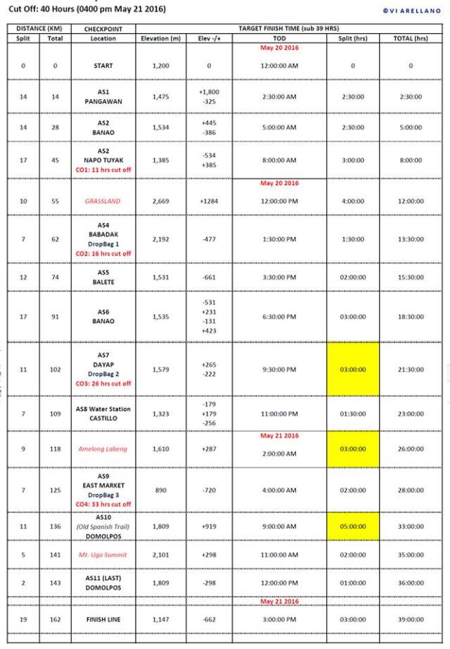
Cheat Sheet: Time Plan Reference For A 39-Hour Finish
Before reaching Banao, I was able to pass 8 runners and most of them did not have any trekking poles as they deliberately and slowly selected/chose the drier parts of the trail where they would avoid sliding on the muddy road. Even if the course profile on this part of the route is steeply going down, a runner would not dare to run a faster pace with the mud and slippery nature of the trail. So, instead of getting faster and improving one’s pace in this portion, I had to move slowly and deliberately instead of falling down and getting injured in the process. One false or mistake move on my part would mean a fracture or two on my ribs or bones. Better to be safe than landing in a hospital and giving a problem to the RD. One of the runners whom I passed just simply sat beside the trail wearing his raincoat and declared himself as DNF for having blurred vision! Before reaching Banao, the sun was already on the horizon, the rain had stopped and I could see signs from the cloud formation that the day will be a hot one!
As I looked at my watch, I was already delayed for almost one hour due to the muddy road (and slow start up to Pangawan) and decided to continue without dropping by at the Banao Aid Station. Knowing the different natural and free-flowing water sources along the trail, I was confident that I could easily refill my hydration bottles and bladder with water. It is a steep downhill run from the Banao Aid Station until you reach the bottom where one has to cross the 2nd Cable Hanging Bridge along the course. From the bottom, one has to go uphill again until one will be running along the edge of a mountain where on your left is a big & wide raging river. This is where you will pass the famous Sitio Happy, Kabayo where one will be running on the middle of a mini-rice terraces. Just be careful on your footing that you might land or fall down on the lower level rice terrace which has a height of at least 10-12 feet. There are more Cable Hanging Bridges to cross along this part of the course and be careful not to slip on those wooden planks. The course seem to be flat as the trail becomes flat as one has to run beside the raging river. Sometimes, you will run a flat trail with a narrow irrigation canal on your left side after passing the ABAT Elementary School until you reach a “meadow” where some houses are located. From the houses, it will be a deep descending part of small rocks on the trail where is a wooden fence on your right and a big trunk of fallen tree on the middle/left side of the trail. Take advantage of picking up your pace on these flat and descending parts of the course. After crossing the longest Cable Hanging Bridge in Kabayo, be ready for the next 7 kilometres of relentless climb up to the trail intersection/crossing of Napo-Tuyak which is still one kilometre away from the Aid Station/Checkpoint.
The Longest Hanging Bridge Towards Napo-Tuyak
I started to slow down on the last 5 Kilometers to Napo-Tuyak because of the heat of the sun and the steep climb to the crossing/intersection before the Aid Station. It was only on the last 2 kilometres that I thought of ingesting some solid food and taking in my first Salt Tablets that I was able to recover some strength to beat the cut-off time in Napo-Tuyak by 2 minutes. The “pit stop” to eat and rest on the last 2 kilometres was costly that I squandered 20-25 minutes of my “buffer” time.
I was the #124th and last runner to arrive within the cut-off time of 11 hours at Napo-Tuyak (Km 45). How I wished there was an Ice Cold Coca-Cola drinks to greet me at the Aid Station but there was none. The newly-cooked Camote just arrived and I picked-up one or two pieces which were still hot to eat. I put them in my pocket and proceeded to the store where I could buy some Coke. After eating some solid foods and the newly-cooked camote with the Coke, I started my climb as the last runner to Grassland without any hope of arriving at the next Aid Station/Checkpoint within the cut-off time of 16 hours!
It is a consolation that it was my 4th time to trek on this very steep climb from Napo-Tuyak to Babadak no matter what time will I arrive at the next Checkpoint. There was still light as it was before sundown when I finally reached the Grassland. There is no need to bring out my Cellphone as I was here for so many times since started in trail running. From the Grassland, I was on a Hiking Mode to Babadak and hoping that I would be transported back immediately to Kayapa for my shower, tooth-brush, hot food and warm bed.
I missed the cut-off time of 16 hours in Babadak Aid Station/Checkpoint and I was declared “DNF” (Did Not Finish).
Things To Be Improved To Myself:
Fighting With Age & Body Deterioration——I am so lucky and blessed that I’ve reached this age without any major illness or living a life while taking in some “preventive maintenance” drugs/medicines to buy more time in existence in this world. All I could do is to maintain my health/physique and continue what I love doing which is trail running and hiking up and down the mountains. I will be going back to Kayapa next year and finish this course and be declared as the “Oldest Finisher in this Event”.
More Mileage, More Vertical Distance But More Rest——For one to successfully finish this race within the cut-off time of 40 hours, one needs the whole year to train and prepare for it. An average runner knows what is meant by periodization and one must follow this principle of training. For my age, I would strictly follow this principle and make the H1 as my A-1 Priority Race and consider the rest of the races of the year as part of my training and evaluation leading to this Main Event. The training cycle of 3-4 weeks will be observed as to give time for my body to rest and recover for the workouts I’ve put in to my body. Hopefully, I will be devoting more sleeping hours during the days and nights during my training period.
Strengthening Exercises——My strengthening exercises and drills at the Gym for 4 weeks leading to the race complemented or substituted in some of my absences and missed trail running days in my weekly schedules. I did not feel any attacks of cramps or tightening of my muscles on my legs and arms except for some pain on my lower back which needs more “core exercises” during my climb from Napo-Tuyak to Grassland. I think those gym workouts which were concentrated on my leg muscles to include my butt muscles had greatly helped in my run and hike without any signs of any pain or developing any injury to my legs.
Tool or Devise To Remind Me To Eat——I usually use the “beep” sound of my watch every time I complete one mile as a reminder for me to take in my liquid and food but most of the time, I would not hear the sound while on the run. There are times also that I become hard-headed not to drink or eat even if I hear the sound and focus more on what I see in front of me while running. I think I have to practice or train on this using my iPhone as a reminder device or use my iPod music, too! My faster pace between Banao to Kabayo and then to Napo-Tuyak contributed on my lack of concern on my nutrition to the point that I forgot that I had with me in my Hydration Pack lots of Clif Chews which could be eaten easily and gave me the needed energy just like when I ran the TransLantau 100. Age is catching so fast on my memory that I forgot also to take my Salt Sticks/Tablets on the early part of the race when the sun was out and I was sweating profusely and only to remember to take in some when I was about to be totally drained from my energy on the last 2 kilometers to Napo-Tuyak! Next year, this thing will never happen again! Can anybody suggest those “talking” Applications to be downloaded for my iPhone?
Weather, Expect For The Worst——I’ve used my ALTRA Superior 2.0 in my successful runs for the Translantau 100 and Four Lakes 100 but it did not perform well on muddy and slippery trails of H1. Aside from not being aggressive on holding my feet from sliding on muddy trails, the insole kept on folding-up front inside my shoes! I thought that a lump of mud had accumulated inside my shoes that I had to dip my feet/shoes on every running water I could pass along the route just to remove the mud inside. I had some slips but I was glad I had trekking poles to balance myself. I think I have to go back to my Inov-8 Mudclaw or New Balance Trail Shoes with Vibram Soles if this event will be scheduled on this part of the year where I would anticipate some rains during the event. As with my Patagonia Jacket, it passed flying colours on what it is used for as a raincoat and warmer outfit to prevent me from the cold winds in the Grassland. I have used a The North Face Waterproof Jacket during my Recon Hike two weeks before the race as it rained from Napo-Tuyak to Grassland and it passed with flying colours, too!
Trekking Poles——I used my almost 4-year old Black Diamond Trekking Poles which is 120 cm in length. I used them in my past TNF Races, Mt Ugo Marathon, Translantau 100s, Four Lakes 100, and CM50 editions and they are very useful. Now that I am becoming an expert on the use of trekking poles, I feel that I need a longer one in size for more stability. I will buy the same brand of trekking poles with 130 cm in length.
Need For More Speed On The Trail——Hardcore 100 is a very unique mountain trail running event. One has to need some Speed or Faster Pace on the first half of the race and then maintain a comfortable jog-walk pace on the second half of the race. If you don’t have a “buffer time” of 3 hours upon reaching the Napo-Tuyak Aid Station/Checkpoint (Km 45), be ready to DNF at the Babadak Aid Station/Checkpoint (Km 62). If you are arrive at the Babadak Aid Station within the cut-off time of 16 hours in good condition, you have a 50-50 chance of finishing the race within the 40 hours cut-off time. In order to have a “buffer time” of 3 hours at Napo-Tuyak, I have to run an average pace of 5.6 kilometres per hour from the Starting Line up to Napo-Tuyak! Considering the total gain in elevation of about 13,000+ feet within the distance of 45 kilometres, the said pace is a very fast one for me. In my training, I could only manage to have my fastest average pace up to 4.9 kilometers per hour with a lower total gain in elevation by almost 3,000 feet. I have one year to improve my average pace appropriate for the first 45K of the course, hopefully! This will be the first thing that I will improve on in order to have a greater chance of finishing the race.
More Recon & Visits To The Route—-Aside from doing more practice runs on the first 62 kilometres of the route (Start to Babadak), it is also a “must” to know and feel how it is like to run and hike from Napo-Tuyak back to Dayap (Km 102) during nighttime. From Dayap to the Finish Line is the “reverse” version of the Four Lakes 100 route but there is still challenge to it as one has to reach the peak of Mt Ugo before going to the Finish Line. Hopefully, I will be able to do my practice runs and hikes by segment or section on this part of the route when the body is already weak and exhausted. We will see!
As a closing note in this post, I know that there are so many younger, stronger, and more experienced trail runners who have declared themselves as DNF in this race, to include our foreign friends/neigboring countries’ mountain trail runners who have finished other challenging races in other parts of the world and this Hardcore 100 event is something that we could be proud of. This international event could not be possible without the vision and advocacy of Jonel Mendoza and his Team to bring Sports Tourism in this part of the country and establish an added economy for the people of Kayapa and its environs. Let us support this event whether you are a trail runner or a volunteer and hopefully, the government and/or private entities will come into play and be aware of this event and come up with “projects” or establishments for better living conditions and accommodations for the people joining this event.
And for those local Pinoy Runners, Men & Women, who took the Podium Finish Positions and up to the Top Ten Overall Ranking, they have proven that they could Break The Course Record in the previous year/s and even performed well within the standards of the world’s elite international trail runners. This outstanding performance of our Local Trail Runners shows and proves that we can compete among the top international elite trail runners in the world. I just hope that our local as well as our multi-national Outdoor Corporate Brands and Private Business Establishments, and of course, our Government will have the INITIATIVE and CONCERN to bring these outstanding trail runners to international competitions and exposure.
To those who experienced running in this event and about to join this most challenging trail running event in the country, always remember, you came to join this event not to brag to have tried or finished it but you came here to prove that you can endure the most painful experience you can inflict on to yourself because of mountain trail running…thus, you will know more about yourself and what you are capable of from the strength of your mind and body.
Congratulations to those who endured the pain and victorious to have defeated the mountains and had successfully finished the race. To those who failed, we have one year to prepare, train, and save some money.
I made a post about the cut-off times of running events in my post in this blog on May 17, 2011. Until this time, I don’t see any reason why Race Organizers/Directors had to impose cut-off times in their events. For the Marathon Races where most of the city roads are closed from vehicular traffic, six (6) hours is a decent time as a cut-off time in order to relieve the riding public of the inconvenience it would bring if the race is extended up to nine or ten or twelve hours. But on second thought, the cut-off time being imposed is not for the safety of the runners of the event but for the convenience of everybody.
In my post, I made mention of some of the popular ultra races in the world with their prescribed cut-off times. It is obvious that Road Ultras have a shorter cut-off times than those mountain trail races, except for the Badwater Ultra Marathon Race. UTMB’s 166K has a cut-off time of 46 hours; Hardrock 100 which is dubbed as the hardest mountain trail ultra in the USA has a cut-off time of 48 hours; Barkley Marathon has a cut-off time of 60 hours where each loop of 20 miles has a cut-off time of 12 hours; and the most prestigious Western States 100-Mile Endurance Race has a cut-off time of 30 hours.
Each of these ultra races has their reason why the Race Organizer/RD have to impose cut-off times. Moreover, there are intermediate cut-off time in every checkpoint along the route which forces the runner to meet such times, or else, he/she would be disqualified. Such intermediate cut-off times are being strictly enforced as race marshals would strip each runner of their race bib or tag and advised not to be allowed to continue the race.
I would surmise also that such cut-off times are being imposed by the Bureau of Parks and Wildlife which manages or administers safety in these wilderness parks as one of the conditions for the issuance of event permits.
Without any reference on these cut-off times, I would conclude that the Race Directors, who are former ultra runners during their prime age, would be able to “test run” the course by themselves and come up with an arbitrary cut-off time based from their personal capability or finish time results. Or maybe, they invited some of their ultra friends to “test run” the course and get the “mean/average” time of the finishers.
When I thought of organizing the Bataan Death March 102 Ultra Marathon Race, it was a challenge for me to come up with a decent cut-off time for the whole race. After conducting some “50K test runs” with my ultra running friends, I was able to come up with the 18-hour cut-off time, where an average well-trained marathon runner would be able to finish a distance of 50K in 9 hours, which way beyond the 6-hour cut-off time for a marathon (42K) race. This is the reason why one of the qualifications of a BDM 102 participant is a Marathon Finisher.
As for the BDM 160, I just added another 9 hours and another 3 hours for the remaining distance of 58 kilometers where I considered the heat and humidity in the country as the main challenge to finish this event.
When I thought of coming with the first trail ultra marathon race in the country, I would conduct by myself a “test run” on the course by dividing the whole distance of 162 kilometers into two parts. Thus, I came up with 32 hours as the cut-off time for the 1st Taklang Damulag 100-Mile Endurance Race which was maintained for the past 3 years/editions.
As I ran through roads and trails in the country, I made sure that I would “test run” any course/route that I would like to be transformed into an ultra running event for the runners.
I never changed on how I would come up with the “cut-off” time for my races. I would “test run” the course and whatever time I would register as my finish time, such time will be considered as the official cut-off time for the ultra event. Considering my present age to run through the course, I think it would be fair that my finish time will be the target time for the younger runners.
It should be noted that Intermediate Cut-Off Time is the time that a runner would leave the Checkpoint.
So, what is my message in this post? It simply means that a well-trained ultra runner could easily finish my ultra races within the prescribed cut-off times. These cut-off times (intermediate and whole course) will be one’s measurement or gauge if proper training and preparation had been made prior to the event. If one could not meet such cut-off times, it simply means that one lacks the proper training for the event.
At The Finish Line: “Test Run” For The 1st ANTELOOP 100K Trail Run
Let us stop bragging ourselves to have finished a race even if you have finished way beyond the cut-off time. Let us stop giving any “finisher’s loot” for these kind of finishers. A TRUE & OFFICIAL FINISHER is one who finishes the race within the prescribed cut-off time for the event.
Tell me a place within Metro Manila where you have a dirt path/road where you can do some trail running. I guess, there is none. That is the problem when our urban planners do not value the need of a place within the city where we can enjoy the environment of the outdoors. I know of some golf courses in the city but you can rarely see trails inside these golf courses and most of them are restricted from pedestrians.
There are places within reach in Metro Manila for about 30-minute drive from the main populated areas but you can not still escape the dirty surroundings of garbage and poor quality of air due to industrial plants’ and vehicles’ fumes. One has to travel at least 1-2 hours away from Metro Manila in order to reach the mountains of Tanay, Tagaytay, Laguna and Cavite. If you have determined a specific trail/s on these places, you can enjoy the outdoors and have a pure experience on trail running away from the populace and the traffic of vehicles.
For the past 10 months, I have permanently shifted to trail running and I had been in the mountains of Fort Magsaysay, Subic, Bataan and Pampanga. These are the following reasons why I love trail running:
1. The Best Air Quality For The Body-–One has to breath a lot of air/oxygen when you are in the trail, whether you are hiking or running. But there is no need to worry as the air you are breathing are pure and unadulterated. The plants and trees all around you will be happy to have your carbon dioxide that you breath out from your lungs! Sometimes, cold winds from the mountains and the sea would hit your body and the feeling is something that is invigorating! Our lungs would be happy to have fresh air to our body. Being away from the populated areas and busy highways/streets, you have a bigger chances of breathing better quality of air. The more you run in the mountains, you have better air to breath. And once you reach the forest, the air is cooler and you have the best air quality in the area. Sometimes, there are places where it is hot and humid but simply hydrating oneself regularly would solve the problem. There are also creeks and streams where you one can douse cold water to your hot body.
2. Strengthens Joints Up To The Smallest Muscles, Cartilages, and Tendons—Due to the varied condition of the ground, our feet would land to the ground in different and varied positions and this condition would have a “domino effect” on how our muscles, joints, tendons and cartilages would react on how we run. Instead of being “on the zone” when you are in a road running event, your body is always on alert on the varied conditions of the terrain where you are running. I have observed that my feet and the muscles of my legs had become stronger and I no longer experience any cramps on my calves. Surprisingly, my problem with my right achilles tendonitis just disappeared. As for my knees, I would be able to manage the pain better if I run on the trails because of the softer feeling as my feet would strike the ground.
3. Exercise For The Brain For Quick Decisions—Trail Running makes you aware on what to expect on the 3-10 meters in front of you. Due to the variation of elevation and contour of the trail, whether it is ascending or descending, your thinking process is very active. You have to make quick decisions on how you manage the uphills and downhills depending on your capability. If there are rocks or debris (branches; twigs; and leaves on the ground), one should be quick to decide if you have to jump over or just simply step on them. In crossing rivers, creeks, and streams, one has to quickly see and determine the exposed rocks where one could land ones feet in order to keep ones shoes from being wet. I’ve seen a lot of runners who slipped on muddy trails or tripped on dry trails due to poor or lack of decision.
4. Commune With Nature—If you are running the whole trail course, this reason is a flimsy one as you don’t have the time to appreciate your environment. You don’t have time to look around as your concentration and focus will be the trail in front of you. However, it is suggested that you should rest and sit for awhile on a vantage position where one can observe the surroundings. A camera from ones phone would be appropriate to record and journalize the things that you want to capture as a remembrance on the trail that you have been. Appreciate the surrounding mountains, hills, trees, grasses, and the birds in the area. Take time to breath the air as one would rest within the trail route. One should avoid picking edible fruits along the way; picking some flowers; or bringing home some orchids or ornamental plants from the mountains. It’s enough that one should clean the trails from grasses; thorny vines; and branches of plants. At all costs, we have to preserve the environment if we really dedicated to commune with nature.
5. Gain More Information—With the aid of my Garmin Watch, I would be able to pinpoint and establish prominent features in order to establish kilometer markers along the way. By talking to persons I meet along the trail, I would be able to know the name of the place; what direction the trail would lead me or find out where I can get water resupply from the creeks and streams within the area. It is automatic for me to greet the persons I meet along the trail and tell them what I am doing in the area and where I came from. Don’t let the people within the area come up with some suspicion about your intention in the area, it is much better if you talk to them and hear your purpose in the area. If you drop by a hut/house in the area for your water resupply, find time to talk to the owner or anybody staying in the place. There is a big chance that you will be dropping by that place again in the future.
6. Immersion With The Mountain People-–For many instances, I have requested the mountain people/Aetas to act as guide/s in my trail running adventures. I have known how they live in the mountains and how they earn a living. These Aetas were resettled in the area as a result of the eruption of Mt Pinatubo and most of them came from Zambales. Through my immersion with them for those long hours that I would hike on the mountain trails, I was able to find out how they clean some patches of forested areas in the mountains where they can plant bananas, root crops and vegetables. They cut trees and make them as charcoal in the deep forested areas and carry them in sacks for them to be delivered in their respective resettlement areas where merchants would buy and bring these sacks of charcoal on trucks or vehicles. They would also hunt for wild pigs, monkeys, big lizards (bayawak), wild chicken, and bats for their meat. And during summer, they would look for beehives and gather raw honey from them. And worse, they are free to cut any trees in the forest (without any permit from the local DENR) in the guise that the said lumber will be used to construct or repair of their huts/house in the resettlement areas. How I wish the local government would have the time to immerse themselves with these mountain people for them to know what is happening to the environment and our natural resources. I doubt if these mountain people have any activity to reforest or bring back the vegetation in the mountains. (Note: It had been my habit to bring packs of cigarettes and/or cans of sardines to be given to my friends in the mountains during my regular training runs)
7. Explore The Unknown-–Since I don’t carry any compass, GPS, or map, I just try to look at the horizon and ask my training partner to reach a certain feature on the ground or follow a trailhead and see for ourselves where the trail would lead us. If we are running in our usual trail loop/route and if we see an intersection, we had to explore where the new trail would lead us. This is where we would be surprised to see a more unique and better environment and sights to be seen as offered by the natural resources in the mountains. This is how we discovered our water resupply points and places where we could spend some rest and take our lunch. What surprised me most is the presence of gates and fences in the mountains. It means that somebody has already acquired such area bounded by the fences as a personal property. I wonder how could that be when these mountains are considered as Natural/National Parks.
8. Share One’s Experience To Others—Definitely, the end purpose of these trail running is to come up with a trail running course/route for a trail running event for everybody to experience. It would be best that my trail running events will not be sponsored by corporate brands and I want my events to be exclusively for those who trained and prepared for the event. I really don’t care if I have only four or three runner-participants in these events. The lesser number of participants, the better for the trails and the mountains. I would envision also that the populace within the route would also earn a living out of these events as they provide fresh produce from their orchard to the runners or act as guides/marshals in key intersections in the trail route. If I am training for a particular ultra trail event, I usually share my experiences and the sights I’ve been into in this blog or through Facebook through pictures and stories.
9. Faster Recovery-–This is the most kept secret among trail runners! Whether it is a 2-hour trail run or 12-hour trail hike, I could recover easily after a day or 24 hours! All I need is to stretch properly after the run; hydrate and replenish the fluids that I lost during the workout; take a shower; eat my dinner, and then sleep at least 8 hours. Sometimes, a massage before going to bed contributes to a faster recover but I seldom have that for the past two months of my training. With my age, if I do a 2-hour run on the road, it would take me another 48 hours to recover before I could run again.
10. Specificity Of Training—Obviously, if one is preparing for a trail running event, he/she has to spend more time running in the trails. If you are preparing for a trail ultra, you have to do your training on the trail that has almost the same elevation profile with the race you are going to participate (and have registered). Since I’ve shifted my running races to ultra trail running, I had chosen to spend most of my training in the mountain trails.
Since the time I read the book, Ultramarathon Man: Confessions of an All-Night Runner by Dean Karnazes, I had been introduced to a Mountain Trail Ultramarathon Race Event called “The Western States 100-Mile Endurance Run”. Eversince, I’ve been annually trying to know the winners and “stars” of this event. It is fortunate that in this year’s event, the top 100-milers in the USA and Europe competed in this prestigious race.
As a mental “prep” for the Marathon Runners in tomorrow’s 34th MILO Marathon Elimination Race, I am posting the following article which I copied at the Ultrarunning Magazine’s Online Site. However, it would be much better to continue visiting the links and blogs of the key runners, Geoof Roes and Anton Krupicka for their detailed story about their race.
I hope my readers who will be running their Marathon Race (42K) will be mentally prepared and inspired to do their best in tomorrow’s race. Good luck to everybody and see you tomorrow morning.
Auburn, California, June 26. Geoff Roes of Juneau, Alaska took the lead at mile 89 in breaking the course record at the 37th annual Western States 100, posting a 15:07:04 winning time. Anton Krupicka of Boulder, Colorado and Kilian Jornet of Spain ran neck and neck throughout the day, with Roes biding his time a few minutes back. He reached the river crossing (mile 78) in third, 15 minutes back, and began his final charge. Krupicka dropped Jornet by Auburn Lake Trails, but was caught by Roes four miles later. The two ran within a minute of each other through the Highway 49 crossing (mile 93.3), before Roes pulled away on the stretch to No Hands Bridge (mile 96.7) and opened a six-minute lead, which he maintained to the end. Krupicka, in finishing second, was also under Scott Jurek’s previous course record.
Tracy Garneau of Vernon, British Columbia was the women’s winner, leading most of the race. She posted a 19:01:55 winning time despite fighting Achilles tendon issues the last 20 miles. Meghan Arbogast was second, in an impressive performance at age 49.
The weather was not an ally of the runners, with the high temperature in Auburn reaching 93 degrees F. A record 123 silver buckles were earned by runners breaking 24 hours, besting the 106 in 1997. Out of the 426 starters, a record 327 finished the race within the 30 hour time limit.
Men
1. Geoff Roes, 34, Juneau, AK, 15:07:04 (new course record, old record 15:36:27 by Scott Jurek, 2004)
2. Anton Krupicka, 26, Boulder, CO, 15:13:53
3. Kilian Jornet Burgada, 22, Puigcerda, Spain, 16:04:49
4. Nick Clark, 36, Fort Collins, CO, 16:05:56
5. Zach Miller, 34, Bozeman, MT, 16:55:17
6. Gary Robbins, 33, North Vancouver, BC, 17:06:21
7. Glen Redpath, 44, New York, NY, 17:10:06
8. Ian Sharman, 29, Scaldwell, Great Britain, 17:26:19
9. Andy Jones-Wilkins, 42, Ketchum, ID, 17:31:24
10. Dan Barger, 44, Auburn, CA, 17:36:34
I personally named this place as the “Brown Mountain” (BM) for purposes of describing my running workouts. This is my “new” playground for my hill workouts and mountain trail runs.
Trail Running Towards "Brown" Mountain
From this point, my GF 305 registered a distance of 6.5K from the place where I started with the rest of my elite runners. I was already gasping for air to breath and about to surrender when I reached this point on my first time to run this trail. But the elite runners kept on pushing me as they paced me throughout the run. This particular place has an elevation of 700+ meters!
A Nice 8.5K Trail Towards The Mountain & Endless Trails
After turning at 8.5K mark, I had another almost 6.5K downhill trail towards the Starting area. You might have observed that I am using a racing flat shoes (Adidas Adizero Mana) on this trail run. Well, I am trying to experiment if my old legs’ feet cartilages, muscles, and knees could withstand the impact on the soft & hard trails of this mountain! So far, for two running workouts up to BM, my legs and knees are fine.
My "Guides", Escorts & Pacers!
These elite runners had been doing their workouts here for the past weeks and months in preparation for the 34th MILO Marathon Manila Elimination and this coming September’s CAMSUR Marathon.
A Clear Spring @ 8.3K Mark/Point
This is where we usually turn-around and the farthest our feet could reach (so far!) along an endless trail from the “Brown Mountain” to the other adjacent mountains. There are signs that this spring is being visited by wild pig/boar and deer. I’ve observed that the trail at the side of the BM (Brown Mountain) is covered with dried leaves that give additional cushion to the impact of my feet to the ground. Some parts of the trail are one-track carved on the side of the forested areas by water rushing from the top of the mountain due to rains.
We found some time to drink the water on this spring, wash and pour the cold water on our faces, nape, head, legs and arms. The water was so refreshing! The Aeta family that lives nearby the place said that there are more of these kind of springs along the endless trail and their water are potable. What can I say, this could be a nice playground for mountain trail runners and “serious” runners!


You must be logged in to post a comment.