Jag Lanante: The FIRST Pinoy Finisher Of The Hongkong Four Trail Ultra Challenge (HK4TUC)


When everybody was still sleeping on the early morning of the First Day of the Year 2015, a “low-key” ultra marathon race event was about to start in Hongkong. The ultra event is called the “Hongkong Four (4) Trail Ultra Challenge” (HK4TUC) which had been founded and organized by Andre Blumberg, a German executive based in Hongkong who is a “par excellence” ultra trail runner who lately had finished the Grand Slam of Ultrarunning in the USA and the Lake Tahoe 200-Mile Endurance Run, the first 200-mile trail run done in the United States.

Andre Blumberg, five years ago, had to run the four famous Trail routes in Hongkong for four days, running each trail course each day. The following are the trails: MacLehose Trail with a distance of 100 Kilometers; Hongkong Trail with a distance of 50 Kilometers; Wilson Trail with a distance of 78 Kilometers; and the Lantau Trail with a distance of 70 Kilometers. The total course distance is 298 Kilometers. The total elevation gain is 14,500 meters!

Andre’s feat in running these trails gave him the idea for the other ultra runners to experience the challenge, thus, the birth of the HK4TUC. To make the event more challenging and exciting, he imposed a cut-off time of 60 hours and runners have to run through the trail courses on a reverse direction. If the books or publications about the Hongkong Trails are presented on chronological Stages, from 1-10 or from Start to Finish, as the case maybe, the race event starts from the FINISH area and ends at the START area or from Stage 10 to Stage 1. The clock does not stop when the runners had to be transported from one trail course to another, by land or by the sea ferry.

Starters With The RD (Jeri Chua, Janelle Sleet, Andre Blumberg, Paul Wong, & Jag Lanante)
Starters With The RD (Jeri Chua, Janelle Seet, Andre Blumberg (RD), Paul Wong, & Jag Lanante)

The event’s rules and regulations are very simple. There is NO Registration Fee, No Medals, No Finisher’s Shirt, No Aid Stations, No UTMB Points, No Competition or Rankings, and No Checkpoints. However, runners can take advantage of the convenience eateries/stores and vending machines along the route for their food and drinks. This is simply a “self-support” event. Bragging Rights is the only Prize for Finishing this Event.

After four years of its existence and with an average of 4-5 participants each year, there are only four (4) finishers in this event since January 2011.

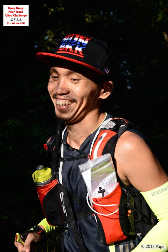
Jag Lanante is the FIRST Filipino to make an attempt on this most dreaded ultra running event and he is one of the four ultra runners who were brave enough to toe the line at the Starting Area in MacLehose Trail. I happen to know him by his name only through Facebook and had never seen him in person. But I have so much respect in him as I found out about his running accomplishments which I gathered from his Facebook Wall from the time we became as FB “friends” since the middle part of last year.

Start Of The MacLehose Trail 100K Leg

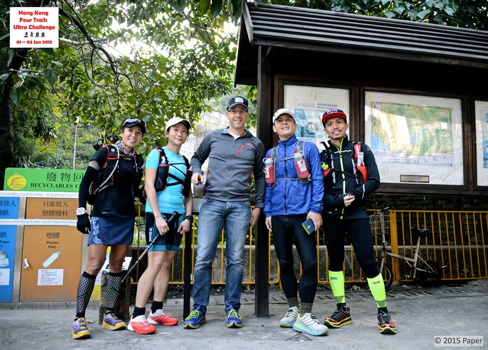
I was sick with Flu (cough and colds) and I was bed-ridden for the duration of this event from Start to Finish but I would be able to glance and peep through my Laptop if my Internet connection is strong from time to time, most specially during midnight and early morning. It was through the HK4TUC Facebook Page that I was able to monitor the progress of the event. Four ultra runners——Two Lady runners from Singapore (Jeri Chua, the favorite one to finish due his previous finishes in the Tor Des Geants and UTMB and Janelle Seet who would take numerous trips from Singapore to Hongkong to train and recon the trails for the past two years; One local runner from Hongkong (Paul Wong); and One Pinoy who is based in Bangkok, Thailand who happens to be Jag Lanante.

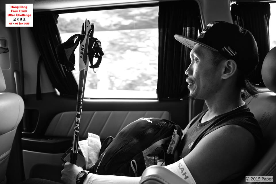
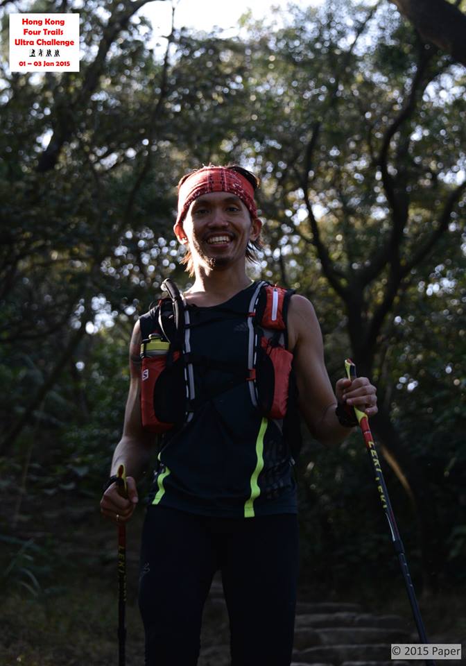
Jag was considered as the “underdog” and the “weakest” among the four runners as he comes from a “flat and plain” Bangkok elevation whose training consisted of 500-meter loop course in a Parking Area in a Private Hospital in Bangkok where he works as a Nurse and he does his running in between his 9-hour work shifts, most of his running workouts are done in the early morning. He would also sneak in and secretly pass through their Security Guards if he needs to use the building’s emergency stairs for his “stair climbing and hill repeats” just to put in some elevation gains in his routine. On his “off days” and weekends, he would go to a nearby Public Park which has a 2.5K loop (flat again!) and do his runs in loops where he would only take note of the number of hours he would run, however, his longest running time would be at least 6 hours. Worst information about him is that this trip for the event is Jag’s FIRST trip to Hongkong! He is not accustomed to the cold weather environment of Hongkong and the hilly terrain of the course. He was equipped with his Salomon Hydration Backpack where he stored his food (all bread), water and extra clothing/jacket; a $7.50 worth of Casio Watch which he was using for the past 8 years; and a borrowed HOKA One One Tarmac Shoes! Initially, Jag did not have with him a trekking pole! He would later borrow the trekking pole from one of the runners who DNF’d midway at the MacLehose Trail (1st trail course of the event). Right from the start of the course, he was already a complete picture/description of a “failure” of an ultra runner who would attempt to finish this dreadful and brutal event, a simple example of a DNF runner!

Jag @ The Wilson Trail (2nd Leg)

And for this reason, my attention would be focused on the progress of Jag Lanante as to where he was during the event. I would make a bet to my “inner self” that Jag would “throw the towel” once he finished the Wilson Trail course (2nd Trail). So, I decided to close my laptop, took my meal, ingest my medications, and went back to bed. I said to myself, “there will be No Finisher” in this year’s event.

I guess, I have to eat my words and committed a mistake of an early misjudgment on the capabilities of Jag!

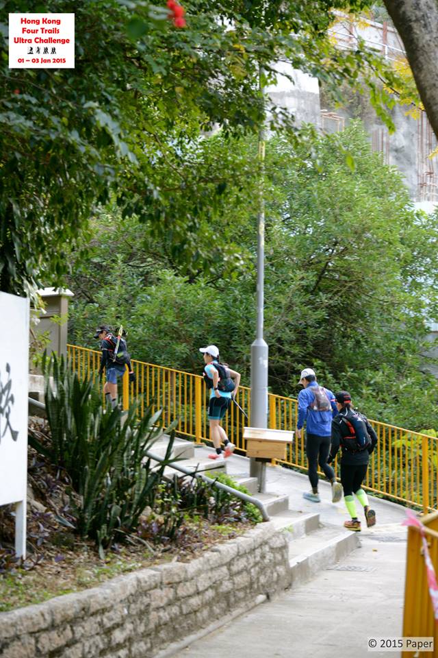
I found out that while I was sleeping on the first day of the year (due to the effect of my medications), the four runners started the event with a perfect Hongkong weather, blue skies and the sun shining hot providing a perfect running weather for the participants. Jeri Chua from Singapore took an early lead from the other three runners and she was ahead of the expected time of arrival in every stage of the MacLehose Trail (in reverse, of course!) but surprisingly had to deal with her recurring knee injury which became very painful on her part and could hardly maintain her targeted pace. She declared herself as DNF after running and hiking on the course for about 14 hours. She was not able to complete the 100K MacLehose Trail course. Jag Lanante and Paul Wong finished the MacLehose Trail together with a time of 21:30+ hours. The last runner, Janelle Seet finished the 1st trail leg in less than 27 hours but she was already complaining of blisters which made her to register a slow finish time to complete the first trail course.

Jag Lanante In Action
Jag Lanante In Action @ Lantau

Jag and Paul were together in their land transport (Taxi Ride) to the next staging area for the 2nd trail course which is the Wilson Trail, a distance of 78 kilometers. They were able to take a nap while being transported to the starting area of Wilson Trail and that was equivalent to a 45-minute power nap! After being served with Hot Soup and some foods at Nam Chung, Jag and Paul started together for the 2nd trail leg, Wilson Trail. However, being a local runner of Hongkong and thorough knowledge of the trails, Paul Wong started to run faster than Jag Lanante that resulted him to pull away for the lead starting at Pat Sin Leng and finally finishing the Wilson Trail in less than 50 hours. He was already on the third day and barely 10 hours more to go before the cut-off time.

What happened to Jag Lanante after Paul Wong left him on the early start along the Wilson Trail? Jag would tell me that he got at least, two “lost moments” at the Wilson Trail——the first lost moment was when he was left alone by Paul when it was so cold and was sleepy to be more focused on looking for the trail markers. He missed the trail marker in going to the 8 Immortals of Hongkong as he was “sleep walking” for 2 hours going down along the trail only to realize that he could no longer see any trail marker. He would go back up again to finally locate the trail marker; the second lost moment was when he reached Taipo (village) as he could not determine from the map provided by Andre as to where the Wilson Trail would re-start again after hitting the village. Jag’s problem was exacerbated when he impulsively asked a Chinese lady who can speak and understand a little English as to where the Wilson Trailhead is located. Jag was instructed by the Chinese lady to go to the end of a river but Jag was frustrated to find out that the lady gave him a false/wrong instructions. Jag started to panic as he went going around the village trying to find out where the Wilson Trail Marker is located. He tried to compose himself, prayed, and relaxed at the same point/location where he entered Taipo. He decided to wait for the arrival of the last runner, Janelle Seet, knowing that the lady has a lot of friends cheering her along the route who are familiar with the route. Finally, Jag joined Janelle for the final push to finish the Wilson Trail leg. Jag’s total “lost moments” time would add up to almost 7 hours! Jag and Janelle finished the Wilson Trail in 54 hours or 2:00 PM actual time on the third day!

Janelle & Jag After Those Lost Moments In Taipo

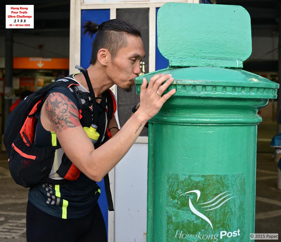
The transition or travel time from the “finish line” of Wilson Trail to the “start of the Hongkong Trail (3rd leg) is very brief/short as both locations are very near to each other. Paul Wong was already ahead despite of the 10-hour remaining time before cut-off time and Jag and Janelle were barely on a 6-hour time before the cut-off time. All the remaining three runners decided to still push through with the event but it was already a “Survivor Challenge” as to who would last to finish the event and be able to kiss the green Mail Post in Mui Wo, Lantau Island.

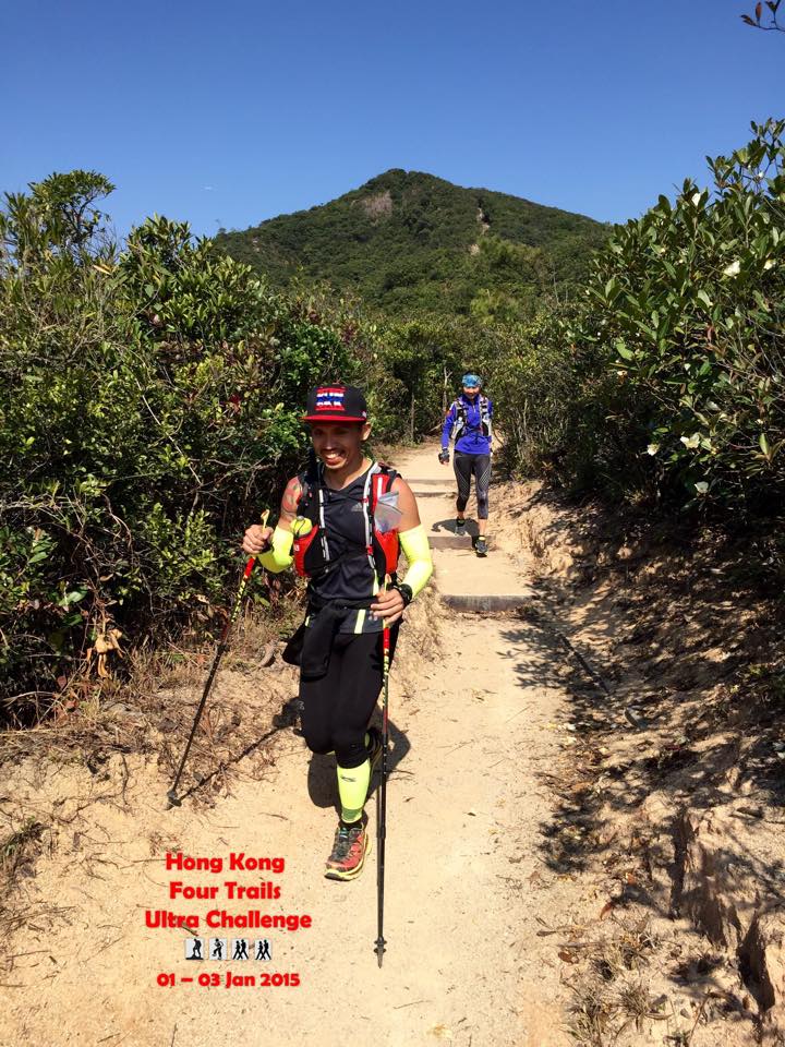
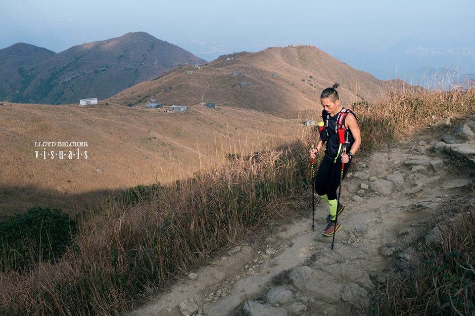
Obviously, Paul Wong was the first runner to start the Hongkong Trail and he was leading for some hours. Jag Lanante and Janelle Seet started later for the 3rd leg of the event. From the very start of the Hongkong Trail, Janelle had to beg off and allowed Jag Lanante to get ahead of her. Jag regained some energy despite numerous and countless “low moments” after finishing 178 kilometers with a very small amount of time to rest and sleep. He was determined to finish the event but he has to reach Victoria Peak and be able to catch up the earliest ferry ride to Lantau Island for the last 70K of the event.

Jag Aboard A Van As Transition From One Leg To Another
Jag Aboard A Van As Transition From One Leg To Another (He Was Awake!)

It was only when he was on the last 6 kilometers of the HK Trail course that he knew that he was already the leading runner among the three “survivors”. He was met by Vic So (2014 HK4TUC Finisher/“Survivor”) along the course to cheer him and informed him that he was able to pass Paul Wong at Km #25 when he went inside a market to eat. Jag finished the HK Trail at Victoria Peak before midnight on the third day and he was able to catch the ferry ride scheduled to leave HK for Lantau at 12:30 AM/Midnight on the 4th day. Paul Wong arrived at the Victoria Peak at 1:00 AM of January 4 while Janelle Seet finished the HK Trail later in the evening. Unknowingly from Jag, the two runners finally decided to “throw the towel” and cease from taking the ferry ride to Lantau. The reason? Extreme exhaustion and sleep-deprived conditions!

Jag Lanante was able to know that Paul Wong and Janelle Seet finally decided not to push through with the Lantau 70K leg from Andre Blumberg who escorted him to Lantua Island. The information was sent through Andre’s cellphone. Jag had already spent 65 hours since the start of the event and he was on the starting line for the Lantau 70K leg!

Slow In Pace But Fighting To Push The Body To The Finish Line
Slow In Pace But  Pushing The Body To The Finish Line @ Sunset Peak, Lantau

I was thinking that Jag was able to sleep during those transition/transfer trips from one leg to another but I was wrong! He told me that he was able to sleep for three times only——first was at the end of Km #33 along the Wilson Trail when he slept while waiting for his order in a Noodle Shop/Eatery; the second one was during the 30-minute ferry ride from HK to Lantau Island; and the third one was a 5-minute nap he requested from Andre while he was experiencing some leg cramps at the Lantau Trail.

Knowing that he was the ONLY runner left in the event and way, way beyond the cut-off time of 60 hours, he asked Andre if he is still be a part of the event and considered as a Finisher in the history of the event. Andre would reply him that this event is not a race and therefore, there are no DNFs, however, if he decides to survive and finish this event, he will get the much-needed support from him no matter how many hours would it take him to reach and “kiss” the green Mailing Post at Mui Wo. Paper, the wife of Andre who is a Thai, informed Jag that the his co-workers in Bangkok are rooting for him to finish the event as he unknowingly seen the cheers and words of encouragement posted by his friends in Thailand through the HK4TUC Facebook Page.

Jag @ Lantau Island (Last Leg)

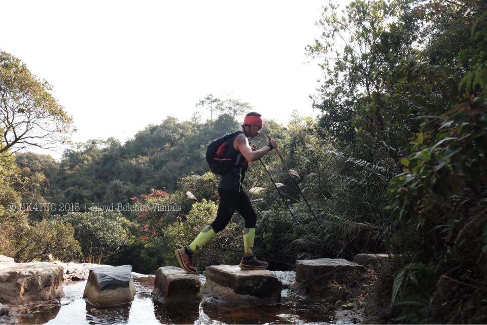
These words of encouragement from Andre and Paper drove and fully motivated Jag to finish the event. Lantau 70K Trail Course is a hard one with 3,300 meters of vertical gain, Jag has to be focused and be able to endure the pain, exhaustion, hallucinations, sleep deprivation, blisters, distractions and there is no room for him to get lost along the course. He has to finish this event.

But there is a more pressing situation and uncompromising reason for him to finish the event! He and his wife have to catch a flight back to Bangkok and he has only 19 hours before his plane leaves at 8:00 PM on the evening of January 4! He thought, at all cost he has to be in that plane with his wife no matter what happens!

Few Meters From The Finish Line!

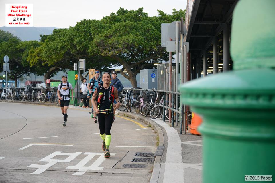
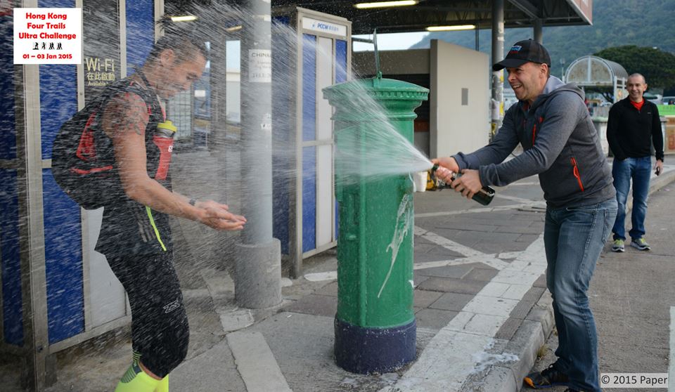
With pure grit and determination despite some doubts for him to finish the last 70 kilometers of the event, Jag was able to finally kiss the green Mail Post in Mui Wo with Andre waiting for him with a Champagne Victory Spray of Moet Rose that served as an informal “body shower” to mask the smell of dirt and perspiration from Jag’s body before proceeding to the Airport. Jag finished the Lantau 70K Leg in 16:30 hours which was in actual time at 5:30 PM of January 4, 2015, 4th day of the event, finishing and surviving the whole event with an official time of 81:30 hours.

The Kiss To The Green Mail Post

After a quick informal conversation/congratulatory greetings and picture-taking among the runners and the RD’s team friends and volunteers, a taxi was waiting for Jag and his wife to bring them to the Airport in order to catch their flight back to Bangkok scheduled to leave at 8:00 PM that evening. I am sure that the 3-4 hours flight time from HK to Bangkok was the best sleep that Jag experienced in his lifetime!

After making sure that Jag had fully recovered from his “brutal but inspirational” finish at the 2015 edition of the Hongkong Four Trail Ultra Challenge, I sent him a Personal Message on Facebook to congratulate him for being the “FIRST Pinoy Ultra Runner to Finish” the said event. This Facebook conversation led me to ask some questions about him and his experience during the event. Thus, this story is posted as an inspiration to all the readers of this blog, most specially to our Pinoy Ultra Runners.

And The Champagne Victory Spray By The RD
And The Traditional Champagne Victory Spray By The RD

To answer the mystery on the toughness, pure grit and determination of Jag to finish the event as I am not convinced that his one year training on a “flat, plain and boring” loops in his Hospital’s Parking Area and Bangkok’s Public Park prepared him for the event. There could be more information about this humble and ever-smiling runner as to why he has a “strong heart and a positive mental attitude” to finish this most feared ultra running event among the locals of Hongkong and other ultra runners in nearby Southeast Asia, despite the fact that the event is free; a chance to tour the nice scenery of Hongkong on foot; and a good reason to shed off those accumulated calories brought about by the Holiday Season.

My fellow ultra runners would be able to read “between the lines”, so to speak, as I mention the following facts about Jag and his “running career” and background:

1. Jag is 29 years old, a native of Davao City and had been an OFW as a Nurse in Bangkok, Thailand for so many years. He started to train and run for the past 4 years. He is married to Kathleen Faith who works also in the same hospital with Jag. They don’t have any kids.
2. He finished his primary and secondary schoolings in Davao City but decided to finish his BS in Nursing at Mountain View College in Bukidnon after his parents would not allow him to be admitted to the Philippine Military Academy (PMA).
His best finish time for a Marathon Race is 3:10+ hours which was held on his Birthday, four months after his Boss introduced him to running.
3. His first ultra was the 2013 TNF 100 but four months later, he finished as #10 in a 50K trail run event, both were held in Thailand. And since then, he tried his best to run everyday and prepare for the HK4TUC.

Lastly, I would ask him what would be his next ultra race. He replied to earn his FIRST 100-Mile Buckle in one of the ultra races in the Philippines if his work schedule’s leave would match the scheduled date of his choice of event. But he gave me a 100% assurance that he will be back for a repeat with a better performance at the 2016 edition of the HK4TUC.

I replied back to him immediately, “It will be a honor running with you on the First Day of 2016 HK4UTC on the early miles of Stage 10 of the MacLehose Trail!” His silent answer is depicted on the picture below!

The Ever Smiling & Humble Jag Lanante

Congratulations Jag, the FIFTH Finisher in the history of the Hongkong Four Trails Ultra Challenge!!! My snappy salute to you and from the rest of the Pinoy Ultra Runners here in the Philippines and abroad!

More pictures and stories/details of the 2015 HK4TUC can be seen here: https://www.facebook.com/HK4TUC

(Note: Photos Courtesy of Paper & Lloyd Belcher of Hongkong)

Official Results: 2nd ANTIQUE 100/50-Mile Endurance Run


2nd ANTIQUE 100/50-Mile Endurance Run

September 5-7, 2014

Provincial Capitol, San Jose De Buenavista, Antique To Army Transient Facility (ATF), Barangay Caticlan, Malay, Aklan (Via Nabas, Aklan)

32 Hours

ANTIQUE 100-Mile Endurance Run

1. Lao Ogerio (Champion, Overall)———25:58:55 Hours

2. Patrick Earl Manulat (1st Runner-Up, Overall)——–26:51:37

3. Rex Gonzales (2nd Runner-Up, Overall)——–27:24:58

4. Dindo Diaz———-28:01:02

5. Rhoda Oporto (Champion, Female/Course Record)———28:22:56

6. Merbert Cabral——–28:32:50

7. Bong Dizon——–29:35:38

8. John Andrew Alcedo——–30:37:12

9. Dante Adorador——–30:40:50

10. Lyra Valles (1st Runner-Up, Female)——–31:12:56

11. Tess Leono (2nd Runner-Up, Female)——–31:29:23

12. Michael Dauz————31:29:24

19 Starters In Front of the Antique Provincial Capitol
Overall Champion Lao Ogerio
Lady Champion Rhoda Oporto

————————————————————————————————————

ANTIQUE 50-Mile Endurance Run

15 Hours

1. Loradel Hanopol (Champion, Overall)——–13:46:10 Hours

Overall Champion Loradel Hanopol

Congratulations To All The Finishers!

Update: 3rd Fort Magsaysay To Dingalan 60K Ultra Run


Details of the Event are posted on the Facebook’s Event Page for the 3rd Edition of this Race. The start time of the race will be at 4:00 AM and the cut-off time is 12 Hours. The following is Facebook link.

https://www.facebook.com/events/538929012834707/

Basic Rules and regulations are stated on the link below:

https://baldrunner.com/2011/06/22/update-pau-fort-magsaysay-60k-run/

Past Results and Finishers on the 1st and 2nd editions are posted below.

https://baldrunner.com/2011/07/18/result-pau-fort-magsaysay-60k-ultra-run-2/

https://baldrunner.com/2012/08/27/result-2nd-pau-fort-magsaysay-to-dingalan-60k-ultra-run/

Good luck to all the runners.

(Note: The Race is a GO even with only 20 runners! This is a RAIN or SHINE Event!)


Picture Of The Week #8


Picture Of The Week #3


(Note: For more pictures of the 3rd T2N 50K Ultra Run, please visit http://www.facebook.com/#!/pages/JAvellanosa-Photography/284963211523134)

Picture Of The Week


Starting this week, I will be featuring a picture which I would like to share to my readers/visitors of this blog. It could be a place or anything that is related to running and other outdoor activities. It could also be a food, a running apparel, or somebody whom I’ve met along the way during my running adventures. I will let the picture speaks for itself.

So, this is the first Picture of the Week in this blog:

At Sitio Happy, Barangay Kabayo, Kayapa, Nueva Vizcaya

(Note: Picture was taken in Sitio Happy, Barangay Kabayo, Kayapa, Nueva Vizcaya)

Steps In “Peak Bagging” & Suggested “Tips”


The following are my personal suggestions if you want to experience “peak bagging” in any of our mountain peaks. It is assumed that you are already a seasoned runner, being a trail runner is one of the qualifications for such an experience, and it is better if you are a marathon runner. However, it is best if you are already a seasoned mountain trekker, hiker or camper.

1. Have a Plan. If you have a steady job or work where you earn a living, planning for a “peak bagging” experience takes a lot of consideration. You need ample time, scheduling, financial support and lots of positive motivation to push through with your plan. Once a quarter (every 3 months) would be a nice schedule or every time there is a long weekend (3-day vacation). The location of target mountain should also be considered in terms of its accessability from your place of origin. Of course, it will be more expensive if the location is farther from your place.

If you have a family, bring your family with you and share your passion to your wife and to your kids. If they are not interested with your outdoor activity, you can bring them with you to your destination and have them stay in a resort or place where there are other alternative outdoor activities to be experienced.

If you are a retiree, like me, enjoying your time and have a love for sports and outdoor adventures, then going out of the city and looking for different places, “peak bagging” is better than reading the news dailies, watching the TV or letting the days passed by in shopping malls/coffee shops or spending a lot of time in your car due to traffic in the metropolis.

2. Make your own research. There are lots of mountaineering resources in the Internet for your mountain destination. There are also mountaineering groups on Facebook where one can get information direct from the person you want to contact. At least, you must have a FB account to have access on these groups.

My favorite mountaineering resource in the Internet is our very own Gideon Lasco at http://pinoymountaineer.comas he categorized each mountain peak by regions and he recommends an ITINERARY for each mountain visit. However, other important data for a runner to know are not stated in his description of each mountain. Mountaineers don’t usually measure their trek to the mountain peak in terms of distance (number of kilometers/miles) but in the number of hours it would take the hikers to reach the summit. So, if they say that a hiker/camper could reach a certain peak in 5-6 hours, an average trail runner could run to the peak in 2.5-3 hours, one-half less the time for a camper/hiker to reach his destination. Faster runners could do it 1/3 of the time a hiker can do to reach the summit. However, other detailed data and information can be gathered from the comments of the his readers in every post in his website.

3. Train for Hill Running. In “peak bagging”, you need to run when the trail is flat or when you are descending along the trail and brisk walk when the trail is uphill or steep incline. For you to be consistent and faster in reaching the summit, your legs must be strong. Strong legs are developed by hill repeats as it mimics your leg turn-over during trail running. As an alternative to hill repeats, one can do strengthening exercises in the gym or at home. One can do some leg squats, lunges, stair walking and core exercises anytime of the day!

4. Prepare your apparel & equipment. Your normal running kit would suffice but as you go higher in elevation, the temperature would become colder. It is a must that you bring a light jacket stowed on your backpack/camelbak which you can use when you are freezing cold. Hand gloves are also advisable as the temperature would be freezing on top of the mountain. If your hands are starting to be numb and cold, it is a signal that you must start your descent from the mountain. Water-proof jacket is also helpful as most of the higher mountains would receive some rains usually when they are covered with clouds. Runners cap is also mandatory as it keeps the escape of heat from your body and at the same time protect your head from accidental “head-butts” from fallen trees and some branches as you pass underneath them. Hydration pack is a must! If you want to stay longer in higher summits, prepare to bring a bonnet that would cover your head and ears.

5. Prepare For Your Hydration/Nutrition. I usually bring water only in my hydration system. I was surprised that my Nathan bottle filled with water was the only water supply that I brought when I “peak bagged” Mt Pulag for a distance of 15 kilometers. Maybe its the cold weather on the higher altitude and the raining prevented my body from losing more perspiration. I usually bring “power bars” and gels in my “peak bagging” activities. They are lighter and my stomach is already used to them. At the Mt Ugo Trail Marathon, I brought my Nathan “Sprint” Handheld Bottle for my Gatorade Mix even if I was holding trekking poles. Gatorade was my extra source of electrolyte if my “peak bagging” activity is a race/competition.

6. Travel Light. I use racing flats/minimalist shoes (NB MT 101) and compression shorts & shirts on my mountain running. If I use Camelbak Hydration Pack, I only fill 1/2 up to 3/4 full of water in its bladder. I only carry minimal number of gels, power bars and Gatorade mix in my pack. Sometimes, I would pack the lightest windbreaker to my pack instead of those heavier outdoor technical jackets. My ASICS Windbreaker which I bought in Jeju, South Korea could be the lightest windbreaker that I have among my running kit. Hopefully, I would be able to buy the Patagonia Nano Jacket, my “dream jacket” for higher altitude “peak bagging”, in the near future. It can be folded and stowed in your packet.

The cheapest version of a jacket/windbreaker/poncho which you can bring is the black commercial trash bags that are available in the supermarket. Get the largest size of trash bags in the market. Simply make a hole on the closed end of the bag where you can insert you head, thus, you have a raincoat for your body and backpack. It is a must to carry at least 2-3 pieces of these black trash bags in your daypack as they serve also as trash bags for the litter you could see along the trail, camping areas or at the peak of the mountain.

7. Trekking Poles. A pair of trekking pole is an invaluable equipment for an old trekker/hiker like me. They are useful in crossing streams and rivers; keep you balanced on uneven and slippery grounds; provide anchor and support for stronger lifting of the body on steep ascending parts of the mountain; and lessen the impact of ones feet on the ground. It takes a simple time to practice to use these trekking poles. It is advisable to use those “bike gloves” (half of the fingers are exposed) when using trekking poles to avoid blisters on your hands. On descending and flat parts of the trail route, I would carry them as if they are my batons in a running relay.

8. Prepare For Contingencies. In trekking/peak bagging, you should always “respect the weather”. If the weather would not allow you to reach the peak, it is best to retreat and make another attempt on a day with good weather. The mountain will always be there, it will never leave from his location. In a good weather, if you start your “peak bagging” in the morning, expect to reach the peak when the sun is already on top of you which means that it is already noon time. The heat of the sun would make you perspire some more and you must be able to hydrate yourself regularly. In case of any encounter with the wildlife, like snakes, deer, wild pigs, cows, or bats, just ignore them and don’t disturb them. Your main mission is to reach the peak of the mountain and not as a hunter.

9. Invest On A Light & Reliable DayPack. A DayPack can store your hydration needs (water bottles + 1.5-liter bladder), additional clothing apparel, first aid kit, food, electrolyte tabs/mix, lighting equipment, and trekking poles.

10. Know Some Protocols/Etiquette/Culture of the People

a. In popular mountains which are being visited by most campers/mountaineers, you need to pay a permit fee and attend an orientation lecture from the personnel of DENR. It is best to register yourself to the barangay hall/barangay officials where the mountain/trailhead is located or to the nearest police or military unit/detatchment in the area before pursuing your activity. On the same manner, inform them on your departure from the place. There are some barangays that would ask P 20.00-P 40.00 as permit fee per person in lower elevation mountains.

b. Be prepared to get a “guide” for a fee. The guide must be requested from the Barangay Officials so that there is accountability in case of any complaints from the hikers. In Mt Apo, I paid P 350.00 for my guide but I paid him an extra tip of P 150.00. In the Ambangeg-Pulag Trail, I paid P 500.00 for my guide which is good up to 5 persons. But for the longer and harder Akiki-Pulag Trail, a guide will cost you P 1,800.00. Even if I don’t need the services of a porter, it is worthy to note that each porter is being paid a minimum of P 500.00 for every 15 kilos of weight. I always see to it that I have a guide in all my “peak bagging” feats.

c. LNT or Leave No Trace. This is the number ONE Rule in any outdoor activity which is “common sense”. Except for Mt Pulag, all the other mountain trails and peaks that I bagged have trashes. I really don’t know if the locals are the one’s littering their trash along the trails and on the peaks or the visitors.

d. Silence Means Good Weather. There is no point why hikers/trekkers would shout on the top of their voice if they see nice scenery and vistas along the mountain trail or while they are at the peak of the mountain. There are also groups of campers that would bring intoxicating liqour on the peak of the mountain and drink to their hearts content and noisy as a result before retiring to their respective tents. Other would mimic or answer the sounds from the birds through their loud voices or involve themselves in loud conversations and laughter while hiking along the mountain trail. All of these are “toxic or pollutants” on the peaceful environment of the forests and the mountains. Local people would predict unfavorabe weather a day or two after such “noise” are done in the mountain!

e. Smile & Greet Everybody you meet along the trail. Find time to talk to them even for a few seconds. Your message should be clear that you are there to simply have a quick look of the place or just passing through. Always be positive on your comments and observation of the place.

f. Most of the mountains in the Cordillera Region & along the Bansalan Trail to Mt Apo have vegetable farms on the foot and slopes of the mountain. You should not mess up or step on the growing plants on these garden/vegetable farms. Never try to harvest or pick any of the vegetables or root crops as you pass by these farms. Most of the farms have cabbage, carrots and potatoes.

11. As much as possible, make a journal or document of your peak bagging activity in every mountain that you visit or attempt to make in reaching a summit. There is no shame if you could not make the grabbing in your first attempt as the mountain will always be there waiting for you. If you have a Garmin/GPS Watch, it would be nice to get the following data: Duration of Peak Bagging Activity from your specific Starting Point to the Peak and back; Distance recorded; Altitude of the Peak; Profile Elevation; Average HR; and other data taken from the equipment. Your personal experience will somehow inspire others to go to the outdoors and be interested in “peak bagging” activity.

(Note: Pictures from Mt Pulag, Mt Natib, Mt Ugo, and Mt Timbac)

#2 “Peak Bagging” @ Mt Natib, Bataan (1,287+ MASL)


March 29, 2012 @ Mt Natib, Barangay Tala, Orani, Bataan

Mt Pulag is more than twice as high as Mt Natib in Barangay Tala, Orani, Bataan.

Exactly 14 days after Mt Pulag’s “peak bagging”, I was on my way to Bataan and try find out if I can reach the peak of Mt Natib within half day. It started with a simple Personal Message on Facebook with a “friend” who happens to be the Military Commander of the Northern & Central Luzon Areas and then later with telephone calls to two subordinate commanders whose areas are within Bataan and other provinces in Central Luzon. After 12 hours from the time I sent a PM on Facebook, everything was set and I could run and hike up to the peak of the famous Mt Natib the following day.

Two days before joining the 1st King of the Mountain Mt Ugo Trail Marathon, I was on my way to Balanga, Bataan to visit the Commander of the 7th CMO (GWAPO) Battalion, Colonel Benny Doniego, who gladly received and escorted me to the 73rd DRC Detachment in Barangay Tala, Orani, Bataan where I would start my run & trek to the peak of Mt Natib. I was surprised that he prepared a breakfast for me and my staff! It was nice to see Col Doniego after I’ve retired from the military service for the past almost 5 years. He happens to have served under me when I was assigned at the 7th Infantry Division in Fort Magsaysay.

Not only did Colonel Doniego prepared a breakfast for me, he even went to the extent of providing me with one officer and one team/squad of soldiers (9 soldiers) as my escorts. His parting words for me was that there will be fresh coconut juice and my favorite dish of “sinampalokang native na manok” waiting for me as soon as I arrive running/trekking from Mt Natib for lunch! Wow! What a nice incentive to finish the activity in a faster mode!

With military escorts infront and on my back, I started my run/hike from the Philippine Army Detachment at 9:30 AM. From the starting point, everything was going uphill until I reached the place which they call “Pinagbutasan” which happens to be a wide man-made “pass” or “breakthrough” on a mountain so that a trail was made on the other side of the mountain. There is a steel gate/fence that protects the unnecessary use of the trail from 4-wheeled vehicles. From this point, you could see the nice vista and mountains/ridges overlooking the towns of Morong and parts of the Subic cove.

The trail is wide with hardened soil/earth on the first part of the route from “Pinagbutasan” and then it transforms to a trail that has lots of stones and rocks. I was informed that the trail was made/constructed by PNOC on their digging explorations on the said mountain years ago. It is worthy to note that Mt Natib is considered as a dormant volcano and I have the suspicion that PNOC was looking for a geothermal source on the said mountain due to its nature as a volcano. Geothermal is one of the alternative sources of power energy. Unluckily, PNOC was not able to find any geothermal source in the said mountain as evidenced by their exploration diggings covered with concrete cement. You can ask your guide if you are interested to find out where these diggings are located.

On this rocky & stony portion of the trail, it is mostly covered with trees and plants. The terrain is not steep and I was able to jog on most parts of this shaded portion of the trail.

It was cloudy and cold during the day that I had my trek on this mountain and I could hardly see its peak. What went into my mind was to be able to reach its peak, take some pictures, and then descend from the mountain peak for my warm and tasty lunch!

After the shaded portion of the trail, an opening of two small hills beckons with tall grasses with the trail on the middle. I could only see the clouds that cover the mountain and the tall grasses as I proceeded with my power hike. More tall grasses on both sides of the single-track trail and then I was told by our guide to turn left towards a clearing.

There was a clearing which they call “Area 1”. It is actually a camping site which is good for 3-4 tents and located on the very base of the peak of Mt Natib. There is a number “06” marker on one of the trees around the campsite. This site is the start of the “final assualt” to the peak of the mountain!

Aside from the soldiers as my escorts, I had with me two of my elite runners who were there as my personal photographer and assistant. We started our final climb towards the peak with me located in between my two runners on single file. The runner in front of me would clear the way for branches and twigs/thorny vines and the other on my back was there to make sure that I will not roll down from the mountain if I tripped or slipped on the rocks. It was raining then and the trail was slippery. It was more slippery on the rocks that we have to use extra effort to push our feet up to the trail.

After 50 meters on the trail, the first runner suddenly stopped and started to retrace his footings backwards. He told me that there is a snake infront of us crossing our path. I told him to get nearer to it and find out where the head is located! He hesitated! I was the one that went nearer to the snake and it was really big but we could hardly see its head! I was about to hold its tail and yanked the whole body out of the thick foliage but I thought that it was not my main “mission” to look for snakes. I am not a hunter and I am not looking for food or for a pet! I am after the peak of Mt Natib, stick and stay focus to the very simple mission! In a split of a second, I instructed my runner on my back to give me my camera and I was able to get a close-up picture of its tail portion as the snake went to the thicker foliage part on the side of the trail.

After the snake encounter, we went higher and higher with more caution. Then, we were faced with a “vertical wall” which is about 10 meters! It’s good there is a nylon rope where one could hold for a nice rapelling experience! However, the challenge was for the the foot anchor to be firm on every leg push and strong arms pull on the rope towards the top of the wall so that there would be no slipping or sliding due to the slippery wet rocks brought by the drizzle. Going up on top of the wall was very slow and deliberate. There is no point of making it fast to reach the top of the wall. Patience is needed in this kind of situation.

After the first wall, there are rocks as part of the trail that I had to crawl just to be sure that I would not slip. Patience paid off. But there was another mini-wall (about 5 meters) with a rope (again!) to be climbed to its top. After passing this last wall, everything was a smooth uphill and in about 50 meters, I was greeted with the Peak/Summit Marker of Mt Natib! Finally, I was able to “peak bagged” Mt Natib!

Three of us, my two runners and I, were the only one who reached the peak. Our escorts were not able to make it! We spent our almost 20 minutes taking pictures and trying to survey the whole area of the peak. There was no view to be seen from the top of the mountain as it was raining and we were covered with clouds. However, I was able to take note of the trashes being scattered on the different places on top of the mountain. In my estimate, the peak can acommodate at least 8-10 tents (solo or double) and there seems to be no attempt to clean and maintain the area. I said to myself, I will be back to clean the mess here on the peak of Mt Natib in the days to come!

We reached the peak in 3 hours. And we were all in a hurry to go back to where we started at the Philippine Army Detachment. However, we needed more patience and more deliberate footing as we went down the two “walls” and rope rapelling. We spent more time in going down on the “final assualt” portion of the mountain. As soon as we reached “Area 1”, we started to jog and brisked walked. Since we did more on jogging and power walking as almost parts of the trail were descending, we made our way to the detachment in almost 2 hours. My GF 305 recorded an elevation data of 1,296 meters at the peak of Mt Natib!

The trip was concluded with a sumptous late lunch at the Battalion Headquarters with Colonel Doniego and I told him of my plan of going back to the peak of Mt Natib during a day with a nicer weather in the company of my running friends. I also told him of my plan to conduct Operation Linis on the said mountain with an specificied date. It will be April 15, Sunday! His answer was affirmative!

Well, this proves that I am already addicted to “Peak Bagging”!

Next….Mt Ugo…in the 1st King of the Mountain Trail (42K) Marathon…after two days!

Hiking


Hiking While On Recovery

This picture says it all about my present condition. I’ve been hiking, sometimes jogging, for the past weeks.

During my dull moments, I’ve been making a lot of research about hiking the wilderness and the art of “fast and light” backpacking and its techniques which are abundant in printed references, journals, and through the Internet. We will see what this activity will offer us in the future as an incoming “senior citizen”.

By the way, do we have a national government office in the Philippines that administers all the National Parks and Wilderness Areas in the country?