
Finally, I got hold of my race packet for the Pasig River Heritage Marathon. But the organizers changed the name of the race into “International Philippine Marathon”. I guess, this is the fourth time that they changed the name of the race and the first time that they changed the route of the race. I hope the picture below will be clear for my co-runners and readers to see.
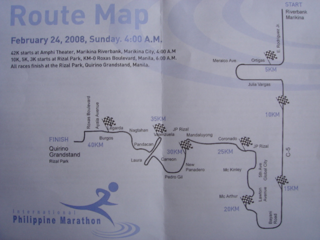
I haven’t seen the actual route but I will try to visualize the route as I recall passing through these roads in the past. The race starts at Riverbank Marikina and runners go south along E. Rodriguez Jr. Avenue–right at Ortigas Avenue (uphill)–left at Meralco Avenue–left at Julia Varga (downhill)–right at C-5 (uphill at the Bridge before Kalayaan & at Market!Market! & McKinley Hill)–right at Bayani Road (my “Heritage Mile” & uphill to Gate 3 Ft Bonifacio)–pass by along Phil Army Golf Course–right at Lawton Avenue–passing through The Fort and exit at the old Gate 1 of Fort Bonifacio all the way to JP Rizal Avenue Makati–runners cross the Pasig River along a bridge towards Coronado (I am not sure if this is the bridge that connects Makati Avenue) & JP Rizal Mandaluyong–turn left at New Panadero–right at Pedro Gil–right at Carreon–left towards Plaza Dilao–turn-around & go towards Valenzuela and back along Pandacan, Sta Mesa–right at Laura–right to Nagtahan Bridge (uphill)–left to Legarda–pass along Ayala Avenue–and Finish infront of the Quirino Grandstand.
Approximate Locations of the following Kilometer Markings:
5K—along Ortigas Avenue
10K—along C-5 (near Toyota)
15K–along C-5 (squatters area)
20K—back of HPA Grandstand along Lawton Avenue
25K—crossing with the street leading to the old Gate 1 of Fort Bonifacio & JP Rizal Makati
30K—New Panadero
35K—Pandacan, Sta Mesa
40K—Legarda
42K—Quirino Grandstand
